1900s (20th Century) Maps of Dawson, Nebraska
Explore 7 historic maps of Dawson from the 1900s (20th Century). These maps offer a rare glimpse into what life looked like during the 1900s — showing old roads, neighborhoods, homes, and landmarks that have changed or disappeared over time.
Whether you're researching your family's past, planning a metal detecting trip, or studying how Dawson's landscape evolved across the 1900s, these high-resolution maps are a powerful tool for exploring the history of this region.
- Focus on a specific era: All maps on this page are from the 1900s, giving you a focused view of this time period.
- See what’s changed: Compare century-old streets, trails, and buildings to today's modern landscape using overlays and satellite layers.
- Research with precision: Use these maps for genealogy, historical research, land use analysis, or educational projects.
- View, download, or print: Maps are fully viewable online in high resolution, and can be downloaded or printed for your own records.
Start exploring Dawson's history through authentic maps from the 1900s. This is your window into the past.
Dawson, NE maps
(7)- 1916 Map of Humboldt
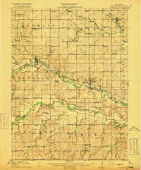 1916 Humboldt1916 Print · USGSRichardson County was a landscape of river-valley farming and emerging drainage projects during the mid-1910s. Researchers can trace the development of rural education and transport through dozens of local landmarks like Windy Lonesome School, Miles Ranch, and the Missouri Pacific line.3 unique versions available
 - 1955 Map of Nebraska City, 1967 Print
 1955 Nebraska City1967 Print · USGSThe four-state region surrounding the Missouri River valley appears here in the mid-1950s, a landscape of rail-dependent market towns and rural school districts. Genealogists can locate family landmarks like the Rock Bluff School, St Oswald Church, and the Clarinda State Hospital.3 unique versions available
 - 1957 Map of Nebraska City
 1957 Nebraska City1957 Print · USGSThe four-state junction of Nebraska, Iowa, Missouri, and Kansas comes alive in this mid-fifties survey of the Missouri River valley. Genealogists and historians can trace the rail-and-road networks connecting Nebraska City, Maryville, and the Squaw Creek National Wildlife Refuge.
 - 1958 Map of Nebraska City
 1958 Nebraska City1958 Print · USGSThe Missouri River Valley and its fertile four-state borderlands are captured here during the mid-century expansion of the regional highway and rail networks. Genealogists can trace family roots through numerous rural landmarks like Moulton School, Shady Grove Church, and the Clarinda State Hospital.
 - 1965 Map of Dawson, 1967 Print
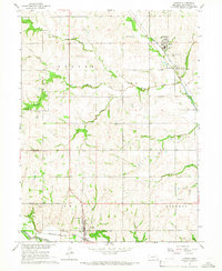 1965 Dawson1967 Print · USGSRichardson County is captured here in the mid-1960s, showing a well-developed network of small rail towns and rural school districts. Family researchers can locate many local landmarks and burial grounds, including the Stratton Cem, Prospect Ch, and the Grand Avenue Sch.
 - 1965 Map of Humboldt SE, 1967 Print
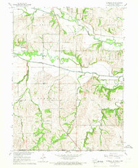 1965 Humboldt SE1967 Print · USGSThe Nebraska-Kansas border comes alive in the mid-sixties as the Big Nemaha River branches across Richardson County farmland. Researchers can locate the Miles Ranch, trace the rail lines of the Chicago Burlington and Quincy, and find family sites like Wild Rose Cem.
 - 1986 Map of Falls City
 1986 Falls City1986 Print · USGSThe Missouri River borderlands of Nebraska and Missouri were a landscape of established colleges and river-bound railroads in the mid-1980s. Researchers can locate long-standing landmarks like Peru State College, the Iowa Indian Reservation, and St Johns Cem.2 unique versions available
End of results
Showing maps 1-7 of 7
Top cities near Dawson
- Falls City historical maps
- Sabetha historical maps
- Humboldt historical maps
- Berwick historical maps
- Morrill historical maps
- Shubert historical maps
See more
Frequently asked questions
- What are the different types of historical maps available for Dawson?
- What is the oldest map of Dawson?
- Where can I purchase historical maps of Dawson for my home or office?
- Where can I download high-res historical maps of Dawson?
- Are there historical topographic maps available for Dawson?
- Is there historical aerial imagery available for Dawson?
- Where are historical maps of Dawson sourced from?