1980s Maps of Saline County, Nebraska
Explore 4 historic maps of Saline County from the 1980s. These maps offer a rare glimpse into what life looked like during the 1980s — showing old roads, neighborhoods, homes, and landmarks that have changed or disappeared over time.
Whether you're researching your family's past, planning a metal detecting trip, or studying how Saline County's landscape evolved across the 1980s, these high-resolution maps are a powerful tool for exploring the history of this region.
- Focus on a specific era: All maps on this page are from the 1980s, giving you a focused view of this time period.
- See what’s changed: Compare century-old streets, trails, and buildings to today's modern landscape using overlays and satellite layers.
- Research with precision: Use these maps for genealogy, historical research, land use analysis, or educational projects.
- View, download, or print: Maps are fully viewable online in high resolution, and can be downloaded or printed for your own records.
Start exploring Saline County's history through authentic maps from the 1980s. This is your window into the past.
Saline County, NE maps
(4)- 1985 Map of Fairbury
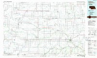 1985 Fairbury1985 Print · USGSThe borderlands of Nebraska and Kansas thrive as a rail and agricultural hub in the mid-1980s. Genealogists and historians can trace local family lands near Fairbury or follow the historic Burlington Northern tracks through Hebron and Deshler.2 unique versions available
 - 1985 Map of York
 1985 York1985 Print · USGSSoutheast Nebraska in the mid-1980s shows a landscape of productive plains and vital transport corridors along the Burlington Northern line. Trace the history of local institutions like Concordia Teachers College and find family sites at Greenwood Cem or Thayer Cem.2 unique versions available
 - 1986 Map of Beatrice
 1986 Beatrice1986 Print · USGSSoutheast Nebraska and the Kansas borderlands appear in the mid-1980s as a thriving agricultural region centered on the Big Blue River. Researchers can trace historic rail routes like the Burlington Northern through hubs such as Beatrice and Pawnee City.2 unique versions available
 - 1986 Map of Lincoln
 1986 Lincoln1986 Print · USGSMid-century development and the rail-and-river economy of southeastern Nebraska are clear in this 1980s survey. Researchers can trace the sprawling rail networks of the Burlington Northern and locate historic sites like Union College and the State Capitol.2 unique versions available
End of results
Showing maps 1-4 of 4
Top cities of Saline County
- Crete historical maps
- Wilber historical maps
- Friend historical maps
- Dorchester historical maps
- De Witt historical maps
- Western historical maps
See more
Frequently asked questions
- What are the different types of historical maps available for Saline County?
- What is the oldest map of Saline County?
- Where can I purchase historical maps of Saline County for my home or office?
- Where can I download high-res historical maps of Saline County?
- Are there historical topographic maps available for Saline County?
- Is there historical aerial imagery available for Saline County?
- Where are historical maps of Saline County sourced from?