1980s Maps of Sarpy County, Nebraska
Explore 3 historic maps of Sarpy County from the 1980s. These maps offer a rare glimpse into what life looked like during the 1980s — showing old roads, neighborhoods, homes, and landmarks that have changed or disappeared over time.
Whether you're researching your family's past, planning a metal detecting trip, or studying how Sarpy County's landscape evolved across the 1980s, these high-resolution maps are a powerful tool for exploring the history of this region.
- Focus on a specific era: All maps on this page are from the 1980s, giving you a focused view of this time period.
- See what’s changed: Compare century-old streets, trails, and buildings to today's modern landscape using overlays and satellite layers.
- Research with precision: Use these maps for genealogy, historical research, land use analysis, or educational projects.
- View, download, or print: Maps are fully viewable online in high resolution, and can be downloaded or printed for your own records.
Start exploring Sarpy County's history through authentic maps from the 1980s. This is your window into the past.
Sarpy County, NE maps
(3)- 1982 Map of Fremont
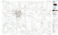
 1982 Fremont1982 Print · USGSEastern Nebraska in the early eighties exhibits a landscape of industrious rail towns and river-fed agriculture. Genealogists and historians can trace the development of Fremont, locate the National Cem, and find landmarks like the Todd Valley.2 unique versions available
 - 1985 Map of Omaha
 1985 Omaha1985 Print · USGSMid-century development and heavy rail infrastructure define the Missouri River corridor between Nebraska and Iowa. Genealogists and local historians can trace the footprints of Offutt Air Force Base, Forest Lawn Cemetery, and the Iowa School for the Deaf.2 unique versions available
 - 1986 Map of Lincoln
 1986 Lincoln1986 Print · USGSMid-century development and the rail-and-river economy of southeastern Nebraska are clear in this 1980s survey. Researchers can trace the sprawling rail networks of the Burlington Northern and locate historic sites like Union College and the State Capitol.2 unique versions available
End of results
Showing maps 1-3 of 3
Top cities of Sarpy County
- Bellevue historical maps
- Papillion historical maps
- La Vista historical maps
- Gretna historical maps
- Springfield historical maps
Frequently asked questions
- What are the different types of historical maps available for Sarpy County?
- What is the oldest map of Sarpy County?
- Where can I purchase historical maps of Sarpy County for my home or office?
- Where can I download high-res historical maps of Sarpy County?
- Are there historical topographic maps available for Sarpy County?
- Is there historical aerial imagery available for Sarpy County?
- Where are historical maps of Sarpy County sourced from?