1980s Maps of Sandoz Ranch, Nebraska
Explore 2 historic maps of Sandoz Ranch from the 1980s. These maps offer a rare glimpse into what life looked like during the 1980s — showing old roads, neighborhoods, homes, and landmarks that have changed or disappeared over time.
Whether you're researching your family's past, planning a metal detecting trip, or studying how Sandoz Ranch's landscape evolved across the 1980s, these high-resolution maps are a powerful tool for exploring the history of this region.
- Focus on a specific era: All maps on this page are from the 1980s, giving you a focused view of this time period.
- See what’s changed: Compare century-old streets, trails, and buildings to today's modern landscape using overlays and satellite layers.
- Research with precision: Use these maps for genealogy, historical research, land use analysis, or educational projects.
- View, download, or print: Maps are fully viewable online in high resolution, and can be downloaded or printed for your own records.
Start exploring Sandoz Ranch's history through authentic maps from the 1980s. This is your window into the past.
Sandoz Ranch, NE maps
(2)- 1985 Map of Alliance, 1986 Print
 1985 Alliance1986 Print · USGSThe High Plains of Box Butte and Sheridan counties come alive in the mid-1980s, centered on the rail hub of Alliance. Genealogists and historians can trace the Burlington Northern line through small sidings and towns like Antioch, Lakeside, and Bingham near the Niobrara River.2 unique versions available
 - 1989 Map of Skunk Lake NE
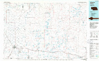
 1989 Skunk Lake NE1989 Print · USGSSheridan County ranching country is captured here during the late eighties, showing the remote plains north of the Niobrara. Researchers can locate family landmarks like the Sandoz Ranch and trace the drainage of Box Butte Creek and the Niobrara River.
End of results
Showing maps 1-2 of 2
Frequently asked questions
- What are the different types of historical maps available for Sandoz Ranch?
- What is the oldest map of Sandoz Ranch?
- Where can I purchase historical maps of Sandoz Ranch for my home or office?
- Where can I download high-res historical maps of Sandoz Ranch?
- Are there historical topographic maps available for Sandoz Ranch?
- Is there historical aerial imagery available for Sandoz Ranch?
- Where are historical maps of Sandoz Ranch sourced from?