1960s Maps of Alexandria, Nebraska
Explore 2 historic maps of Alexandria from the 1960s. These maps offer a rare glimpse into what life looked like during the 1960s — showing old roads, neighborhoods, homes, and landmarks that have changed or disappeared over time.
Whether you're researching your family's past, planning a metal detecting trip, or studying how Alexandria's landscape evolved across the 1960s, these high-resolution maps are a powerful tool for exploring the history of this region.
- Focus on a specific era: All maps on this page are from the 1960s, giving you a focused view of this time period.
- See what’s changed: Compare century-old streets, trails, and buildings to today's modern landscape using overlays and satellite layers.
- Research with precision: Use these maps for genealogy, historical research, land use analysis, or educational projects.
- View, download, or print: Maps are fully viewable online in high resolution, and can be downloaded or printed for your own records.
Start exploring Alexandria's history through authentic maps from the 1960s. This is your window into the past.
Alexandria, NE maps
(2)- 1960 Map of Tobias SW, 1962 Print
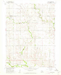 1960 Tobias SW1962 Print · USGSThayer and Fillmore counties are shown at the start of the 1960s, centered on the massive footprint of the Bruning State Airfield. Genealogists can trace family plots at Alexandria Cem or locate the old School No 21 near the Union Pacific line.
 - 1960 Map of Alexandria, 1962 Print
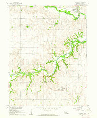 1960 Alexandria1962 Print · USGSThayer County's rolling prairie is captured here in the early sixties as a network of rail lines and river bends. Local historians can trace the foundations of Alexandria and Gilead or locate family plots at Alexandria Cem and St Marys Cem.2 unique versions available
End of results
Showing maps 1-2 of 2
Top cities near Alexandria
- Fairbury historical maps
- Hebron historical maps
- Western historical maps
- Bruning historical maps
- Daykin historical maps
- Tobias historical maps
See more
Frequently asked questions
- What are the different types of historical maps available for Alexandria?
- What is the oldest map of Alexandria?
- Where can I purchase historical maps of Alexandria for my home or office?
- Where can I download high-res historical maps of Alexandria?
- Are there historical topographic maps available for Alexandria?
- Is there historical aerial imagery available for Alexandria?
- Where are historical maps of Alexandria sourced from?