1960s Maps of Webster County, Nebraska
Explore 4 historic maps of Webster County from the 1960s. These maps offer a rare glimpse into what life looked like during the 1960s — showing old roads, neighborhoods, homes, and landmarks that have changed or disappeared over time.
Whether you're researching your family's past, planning a metal detecting trip, or studying how Webster County's landscape evolved across the 1960s, these high-resolution maps are a powerful tool for exploring the history of this region.
- Focus on a specific era: All maps on this page are from the 1960s, giving you a focused view of this time period.
- See what’s changed: Compare century-old streets, trails, and buildings to today's modern landscape using overlays and satellite layers.
- Research with precision: Use these maps for genealogy, historical research, land use analysis, or educational projects.
- View, download, or print: Maps are fully viewable online in high resolution, and can be downloaded or printed for your own records.
Start exploring Webster County's history through authentic maps from the 1960s. This is your window into the past.
Webster County, NE maps
(4)- 1969 Map of Lawrence, 1971 Print
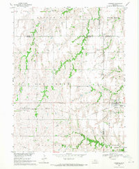 1969 Lawrence1971 Print · USGSLawrence and its neighboring rural communities are captured here in the late sixties at the junction of the Nebraska grain railways. Genealogists and local historians can trace family locations near St Stephens, Rosemont, and Oak Creek Cem.
 - 1969 Map of Blue Hill, 1971 Print
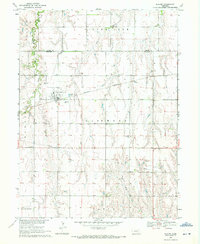
 1969 Blue Hill1971 Print · USGSBlue Hill sits at a historic railroad junction in 1960s Nebraska, where the Burlington Northern line crosses the plains. Genealogists can trace local roots through Trinity, Walker, and Blue Hill cemeteries or follow the waters of Little Blue.
 - 1969 Map of Campbell, 1971 Print
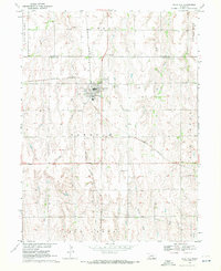
 1969 Campbell1971 Print · USGSThe village of Campbell and the surrounding agricultural townships of south-central Nebraska are captured here in the late sixties. Researchers can trace the Burlington Northern rail line and locate several rural burial grounds like St Ann Cem and Koch Cem.
 - 1969 Map of Bladen, 1971 Print
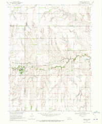
 1969 Bladen1971 Print · USGSThe village of Bladen is captured in the late sixties along the Burlington Northern line. Genealogists can locate family sites at East Lawn Cem, Plainview Cem, and Cloverton Cem scattered across the prairie.
End of results
Showing maps 1-4 of 4
Top cities of Webster County
- Red Cloud historical maps
- Blue Hill historical maps
- Bladen historical maps
- Guide Rock historical maps
- Cowles historical maps
Frequently asked questions
- What are the different types of historical maps available for Webster County?
- What is the oldest map of Webster County?
- Where can I purchase historical maps of Webster County for my home or office?
- Where can I download high-res historical maps of Webster County?
- Are there historical topographic maps available for Webster County?
- Is there historical aerial imagery available for Webster County?
- Where are historical maps of Webster County sourced from?