1970s Maps of Webster County, Nebraska
Explore 8 historic maps of Webster County from the 1970s. These maps offer a rare glimpse into what life looked like during the 1970s — showing old roads, neighborhoods, homes, and landmarks that have changed or disappeared over time.
Whether you're researching your family's past, planning a metal detecting trip, or studying how Webster County's landscape evolved across the 1970s, these high-resolution maps are a powerful tool for exploring the history of this region.
- Focus on a specific era: All maps on this page are from the 1970s, giving you a focused view of this time period.
- See what’s changed: Compare century-old streets, trails, and buildings to today's modern landscape using overlays and satellite layers.
- Research with precision: Use these maps for genealogy, historical research, land use analysis, or educational projects.
- View, download, or print: Maps are fully viewable online in high resolution, and can be downloaded or printed for your own records.
Start exploring Webster County's history through authentic maps from the 1970s. This is your window into the past.
Webster County, NE maps
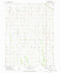
(8)- 1974 Map of Red Cloud NW, 1977 Print
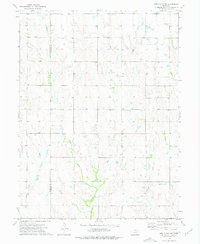 1974 Red Cloud NW1977 Print · USGSThe rural border of Webster and Franklin Counties comes into focus in the 1970s, showing a landscape of prairie creeks and family-named landmarks. Genealogists can trace local roots at Catherton Cem, New Virginia Ch, and Pleasant Prairie Cem.
 - 1974 Map of Amboy, 1977 Print
 1974 Amboy1977 Print · USGSThe Nebraska-Kansas border region comes into focus during the mid-seventies as the Republican River winds past Amboy. Genealogists and historians can trace rail history at Lester Junction or locate family plots at Pleasant Hill Cem and Wagoner Cem.
 - 1974 Map of Guide Rock, 1977 Print
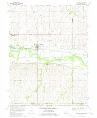 1974 Guide Rock1977 Print · USGSThe Nebraska-Kansas border comes alive in the mid-1970s, centered on the historic river crossing at Guide Rock. Local historians can trace the paths of the Courtland Canal, find early burial sites like Columbia Cem, and locate The Guide Rock (Pa Hur) south of the river.
 - 1974 Map of Red Cloud, 1977 Print
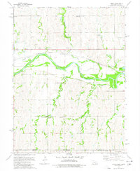
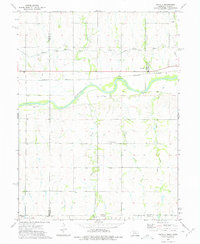
 1974 Red Cloud1977 Print · USGSRed Cloud and the surrounding valley along the Nebraska-Kansas border are captured here during the mid-seventies. Genealogists and local historians can trace rural burial grounds like Murphy Cem and Gust Cem, or locate the curious Indian Oven Ruins near the river.
 - 1974 Map of Red Cloud NE, 1977 Print
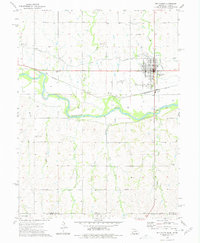
 1974 Red Cloud NE1977 Print · USGSWebster County agriculture is on full display in this mid-seventies survey of the Nebraska plains. Genealogists and local historians can locate rural landmarks like Dane Ch and trace the paths of Indian Creek and Crooked Creek.
 - 1974 Map of Cowles, 1977 Print
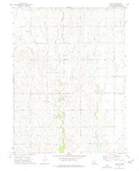 1974 Cowles1977 Print · USGSMid-century Webster County comes into focus here, centered on the railroad village of Cowles and its surrounding farmsteads. Genealogists and local historians can trace family locations through sites like Batin Cemetery, Mulkey Cemetery, and the Burlington Northern rail corridor.
 - 1974 Map of Inavale, 1977 Print
 1974 Inavale1977 Print · USGSThe Nebraska-Kansas borderlands in the mid-seventies come alive through this survey of the Republican River valley. Trace the rail-and-river economy near Inavale and locate rural landmarks like the Walnut Creek Cemetery and Farmers Creek.
 - 1974 Map of Guide Rock NE, 1977 Print
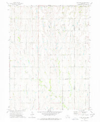 1974 Guide Rock NE1977 Print · USGSSouthern Nebraska farmland in the mid-seventies is mapped here along the Webster and Nuckolls County line. Family historians can locate many rural burial sites such as Eckley Cemetery and Monia Cemetery near the banks of Beaver Creek.
End of results
Showing maps 1-8 of 8
Top cities of Webster County
- Red Cloud historical maps
- Blue Hill historical maps
- Bladen historical maps
- Guide Rock historical maps
- Cowles historical maps
Frequently asked questions
- What are the different types of historical maps available for Webster County?
- What is the oldest map of Webster County?
- Where can I purchase historical maps of Webster County for my home or office?
- Where can I download high-res historical maps of Webster County?
- Are there historical topographic maps available for Webster County?
- Is there historical aerial imagery available for Webster County?
- Where are historical maps of Webster County sourced from?