Old Maps of Blue Hill, Nebraska for Academic Research
Study the evolution of Blue Hill with 10 high-resolution historic maps. Whether you're teaching, researching, or modeling changes in land use, these maps provide essential visual documentation of urban, environmental, and geographic change.
- Analyze long-term change: Track patterns in development, transportation, and natural features.
- Ideal for environmental or urban studies: Support academic projects with primary historical map data.
- Use in the classroom or lab: Educators and researchers rely on these maps to bring historical context to life.
These maps are a powerful tool for teaching, research, and visualizing how Blue Hill has changed over the decades.
Blue Hill, NE maps
(10)- 1898 Map of Superior
 1898 Superior1898 Print · USGSSouthern Nebraska and northern Kansas were dominated by a growing rail network in the late nineteenth century. Genealogists can trace family roots through early settlements like Superior, Nelson, and Guide Rock, or locate vanished tracks of the Kansas City and Omaha R. R.3 unique versions available
 - 1955 Map of Grand Island, 1967 Print
 1955 Grand Island1967 Print · USGSCentral Nebraska is seen here during a period of industrial and agricultural growth, centered on the vital Platte River corridor. Researchers can trace the mid-century footprints of the U S Naval Ammunition Depot and the Cornhusker Ordnance Plant.3 unique versions available
 - 1957 Map of Grand Island
 1957 Grand Island1957 Print · USGSCentral Nebraska and Northern Kansas are shown here during a period of massive hydraulic and military expansion in the mid-fifties. Researchers can trace the development of the Harlan County Reservoir and the massive wartime legacy of the Cornhusker Ordnance Plant.
 - 1958 Map of Grand Island
 1958 Grand Island1958 Print · USGSSouth-central Nebraska thrived as a rail and industrial hub during the late fifties, shaped by the braided Platte River. Genealogists and historians can trace rail lines like the Union Pacific RR through towns such as Kearney or locate the sprawling Cornhusker Ordnance Plant.
 - 1969 Map of Blue Hill, 1971 Print
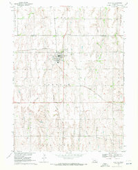 1969 Blue Hill1971 Print · USGSBlue Hill sits at a historic railroad junction in 1960s Nebraska, where the Burlington Northern line crosses the plains. Genealogists can trace local roots through Trinity, Walker, and Blue Hill cemeteries or follow the waters of Little Blue.
 - 1985 Map of Red Cloud
 1985 Red Cloud1985 Print · USGSSouth Central Nebraska and the Kansas borderlands appear in high detail during the mid-eighties as a landscape of river-fed agriculture and rail-connected prairie towns. Researchers can trace the Burlington Northern tracks through Red Cloud or locate the extensive Courtland Canal and Superior-Courtland Diversion Dam.2 unique versions available
 - 2011 Map of Blue Hill, 2011 Print
 2011 Blue Hill2011 Print · USGSCovers Blue Hill, including Adams County, Webster County, and other nearby areas
 - 2014 Map of Blue Hill, 2014 Print
 2014 Blue Hill2014 Print · USGSCovers Blue Hill, including Adams County, Webster County, and other nearby areas
 - 2017 Map of Blue Hill, 2017 Print
 2017 Blue Hill2017 Print · USGSCovers Blue Hill, including Adams County, Webster County, and other nearby areas
 - 2021 Map of Blue Hill, 2021 Print
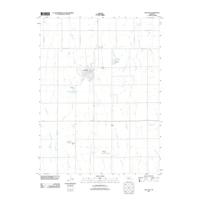
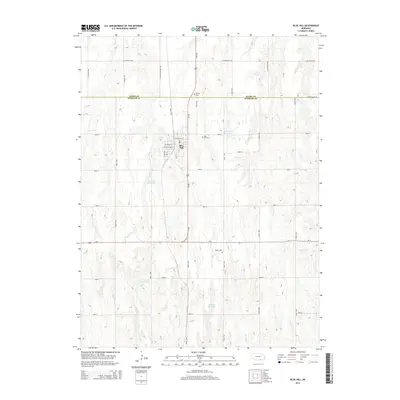
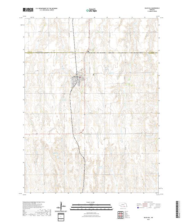 2021 Blue Hill2021 Print · USGSBlue Hill and the surrounding Nebraska farmlands are captured here in a moment of modern agricultural continuity. Researchers can trace the town’s street grid and identify local heritage sites such as Trinity Lutheran Cem and Blue Hill Cem.
End of results
Showing maps 1-10 of 10
Top cities near Blue Hill
- Glenvil historical maps
- Lawrence historical maps
- Bladen historical maps
- Roseland historical maps
- Holstein historical maps
- Ayr historical maps
See more
Frequently asked questions
- What are the different types of historical maps available for Blue Hill?
- What is the oldest map of Blue Hill?
- Where can I purchase historical maps of Blue Hill for my home or office?
- Where can I download high-res historical maps of Blue Hill?
- Are there historical topographic maps available for Blue Hill?
- Is there historical aerial imagery available for Blue Hill?
- Where are historical maps of Blue Hill sourced from?