1940s Maps of Red Cloud, Nebraska
Explore 2 historic maps of Red Cloud from the 1940s. These maps offer a rare glimpse into what life looked like during the 1940s — showing old roads, neighborhoods, homes, and landmarks that have changed or disappeared over time.
Whether you're researching your family's past, planning a metal detecting trip, or studying how Red Cloud's landscape evolved across the 1940s, these high-resolution maps are a powerful tool for exploring the history of this region.
- Focus on a specific era: All maps on this page are from the 1940s, giving you a focused view of this time period.
- See what’s changed: Compare century-old streets, trails, and buildings to today's modern landscape using overlays and satellite layers.
- Research with precision: Use these maps for genealogy, historical research, land use analysis, or educational projects.
- View, download, or print: Maps are fully viewable online in high resolution, and can be downloaded or printed for your own records.
Start exploring Red Cloud's history through authentic maps from the 1940s. This is your window into the past.
Red Cloud, NE maps
(2)- 1940 Map of Red Cloud, 1954 Print
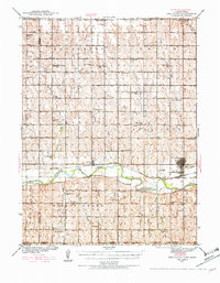 1940 Red Cloud1954 Print · USGSSouthern Nebraska at the end of the Great Depression is characterized by its close-knit rural school districts and river-valley rail lines. Genealogists can trace family roots through numerous landmarks like Catherton Cem, St Stevens Ch, and the Poor Farm Sch.2 unique versions available
 - 1942 Map of Red Cloud
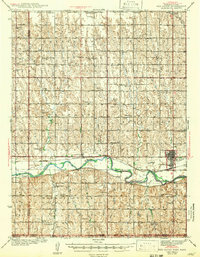 1942 Red Cloud1942 Print · USGSRed Cloud and the surrounding Republican River valley are shown here just before the mid-century, when the rural school system remained remarkably intact. Researchers can trace family roots through numerous sites like New Virginia Cem, Poor Farm Sch, and Inavale.
End of results
Showing maps 1-2 of 2
Top cities near Red Cloud
- Campbell historical maps
- Burr Oak historical maps
- Guide Rock historical maps
- Cora historical maps
- Cowles historical maps
Frequently asked questions
- What are the different types of historical maps available for Red Cloud?
- What is the oldest map of Red Cloud?
- Where can I purchase historical maps of Red Cloud for my home or office?
- Where can I download high-res historical maps of Red Cloud?
- Are there historical topographic maps available for Red Cloud?
- Is there historical aerial imagery available for Red Cloud?
- Where are historical maps of Red Cloud sourced from?