1970s Maps of Middlegate, Nevada
Explore 2 historic maps of Middlegate from the 1970s. These maps offer a rare glimpse into what life looked like during the 1970s — showing old roads, neighborhoods, homes, and landmarks that have changed or disappeared over time.
Whether you're researching your family's past, planning a metal detecting trip, or studying how Middlegate's landscape evolved across the 1970s, these high-resolution maps are a powerful tool for exploring the history of this region.
- Focus on a specific era: All maps on this page are from the 1970s, giving you a focused view of this time period.
- See what’s changed: Compare century-old streets, trails, and buildings to today's modern landscape using overlays and satellite layers.
- Research with precision: Use these maps for genealogy, historical research, land use analysis, or educational projects.
- View, download, or print: Maps are fully viewable online in high resolution, and can be downloaded or printed for your own records.
Start exploring Middlegate's history through authentic maps from the 1970s. This is your window into the past.
Middlegate, NV maps
(2)- 1972 Map of West Gate, 1975 Print
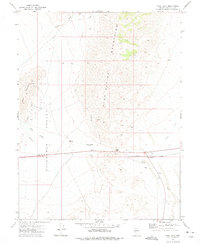 1972 West Gate1975 Print · USGSChurchill County's high-desert mining and transit corridors are captured here in the early seventies. Trace local industrial history through the West Gate Mill (Site) or locate landmarks like Chalk Mountain and the settlement of Middlegate.
 - 1979 Map of Fallon, 1980 Print
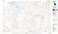 1979 Fallon1980 Print · USGSIn the Great Basin during the late seventies, the agricultural life of the Lahontan Valley meets a sprawling landscape of naval reservations and desert ranges. Genealogists and researchers can locate remote outposts like Frenchman, industrial sites at the Summit King Mine, and the historic Southern Pacific rail line.2 unique versions available
End of results
Showing maps 1-2 of 2
Frequently asked questions
- What are the different types of historical maps available for Middlegate?
- What is the oldest map of Middlegate?
- Where can I purchase historical maps of Middlegate for my home or office?
- Where can I download high-res historical maps of Middlegate?
- Are there historical topographic maps available for Middlegate?
- Is there historical aerial imagery available for Middlegate?
- Where are historical maps of Middlegate sourced from?