1900s (20th Century) Maps of Echo Bay, Nevada
Explore 8 historic maps of Echo Bay from the 1900s (20th Century). These maps offer a rare glimpse into what life looked like during the 1900s — showing old roads, neighborhoods, homes, and landmarks that have changed or disappeared over time.
Whether you're researching your family's past, planning a metal detecting trip, or studying how Echo Bay's landscape evolved across the 1900s, these high-resolution maps are a powerful tool for exploring the history of this region.
- Focus on a specific era: All maps on this page are from the 1900s, giving you a focused view of this time period.
- See what’s changed: Compare century-old streets, trails, and buildings to today's modern landscape using overlays and satellite layers.
- Research with precision: Use these maps for genealogy, historical research, land use analysis, or educational projects.
- View, download, or print: Maps are fully viewable online in high resolution, and can be downloaded or printed for your own records.
Start exploring Echo Bay's history through authentic maps from the 1900s. This is your window into the past.
Echo Bay, NV maps
(8)- 1926 Map of Bonelli
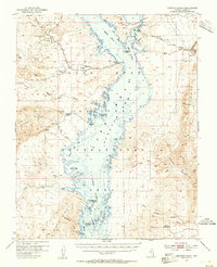
 1926 Bonelli1926 Print · USGSThe Nevada-Arizona borderlands are captured here in the mid-1920s, showing the original river-crossing culture before the landscape was submerged. Researchers can trace the river economy through Bonelli Ferry, the settlement at St Thomas, and local mining at the Calico Salt Mine.
 - 1953 Map of Overton Beach, 1955 Print
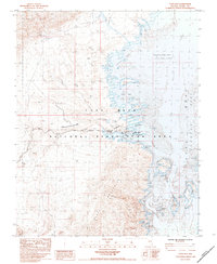
 1953 Overton Beach1955 Print · USGSThe northern reaches of the reservoir appear in the mid-1950s as the rising waters reshaped the Clark County desert. Researchers can trace the submerged sites of St. Thomas and Kaolin or locate mining landmarks like the Nevada Silica Sand Mine and Florence Mine.4 unique versions available
 - 1954 Map of Las Vegas
 1954 Las Vegas1954 Print · USGSLas Vegas and the Mojave Desert are shown in the early fifties as the region's military and recreational footprint expanded. Genealogists and historians can trace the early layout of North Las Vegas, the sites of Indian Springs Air Force Base, and long-established towns like Bunkerville.5 unique versions available
 - 1957 Map of Las Vegas
 1957 Las Vegas1957 Print · USGSSouthern Nevada in the mid-fifties is a landscape of massive federal ranges and the early growth of Las Vegas. Researchers can trace the development of McCarran Field, the expansive Lake Mead National Recreation Area, and the industrial footprint of Henderson.
 - 1959 Map of Las Vegas
 1959 Las Vegas1959 Print · USGSSouthern Nevada in the late fifties was a landscape of rapid suburban growth and massive federal installations. Genealogists and historians can trace early housing at Victory Village, the grounds of Camp Desert Rock, and the remote Tule Springs Ranch.
 - 1962 Map of Las Vegas
 1962 Las Vegas1962 Print · USGSSouthern Nevada is captured here during a period of significant military and industrial growth in the early sixties. Researchers can trace the development of Las Vegas alongside the Magnesium Plant in Henderson and the expansive Nellis Air Force Base.
 - 1983 Map of Echo Bay, 1984 Print
 1983 Echo Bay1984 Print · USGSAs the 1980s began, the desert shoreline at Echo Bay was a hub for recreation and remote living within the National Recreation Area. Researchers can locate specific infrastructure from the Trailer Park and Boat Ramp to the Landing Strip and Echo Mills.
 - 1987 Map of Lake Mead, 1988 Print
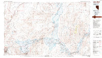 1987 Lake Mead1988 Print · USGSThe Lake Mead region in the late eighties shows a landscape shaped by massive water reclamation and growing desert communities. Trace the reach of the reservoir from Hoover Dam to Meadview, or locate remote desert landmarks like Rogers Spring and the Bowl of Fire.
End of results
Showing maps 1-8 of 8
Top cities near Echo Bay
Frequently asked questions
- What are the different types of historical maps available for Echo Bay?
- What is the oldest map of Echo Bay?
- Where can I purchase historical maps of Echo Bay for my home or office?
- Where can I download high-res historical maps of Echo Bay?
- Are there historical topographic maps available for Echo Bay?
- Is there historical aerial imagery available for Echo Bay?
- Where are historical maps of Echo Bay sourced from?