1980s Maps of Tuscarora, Nevada
Explore 2 historic maps of Tuscarora from the 1980s. These maps offer a rare glimpse into what life looked like during the 1980s — showing old roads, neighborhoods, homes, and landmarks that have changed or disappeared over time.
Whether you're researching your family's past, planning a metal detecting trip, or studying how Tuscarora's landscape evolved across the 1980s, these high-resolution maps are a powerful tool for exploring the history of this region.
- Focus on a specific era: All maps on this page are from the 1980s, giving you a focused view of this time period.
- See what’s changed: Compare century-old streets, trails, and buildings to today's modern landscape using overlays and satellite layers.
- Research with precision: Use these maps for genealogy, historical research, land use analysis, or educational projects.
- View, download, or print: Maps are fully viewable online in high resolution, and can be downloaded or printed for your own records.
Start exploring Tuscarora's history through authentic maps from the 1980s. This is your window into the past.
Tuscarora, NV maps
(2)- 1982 Map of Tuscarora, 1983 Print
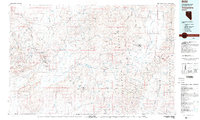 1982 Tuscarora1983 Print · USGSNortheastern Nevada in the early eighties reveals a landscape shaped by mining and high-desert hydrology. Trace the locations of historic extraction sites like Silver Cloud Mine or the Falcon Mines and find remote landmarks such as Hot Sulphur Springs.
 - 1987 Map of Tuscarora, 1988 Print
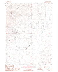 1987 Tuscarora1988 Print · USGSElko County, Nevada, in the late 1980s reveals a landscape where silver and gold mining history meets high-desert ranching. You can trace the footprint of the old Tuscarora townsite and explore nearby workings like the Queen Mine and Stampede Ranch.
End of results
Showing maps 1-2 of 2
Frequently asked questions
- What are the different types of historical maps available for Tuscarora?
- What is the oldest map of Tuscarora?
- Where can I purchase historical maps of Tuscarora for my home or office?
- Where can I download high-res historical maps of Tuscarora?
- Are there historical topographic maps available for Tuscarora?
- Is there historical aerial imagery available for Tuscarora?
- Where are historical maps of Tuscarora sourced from?