1960s Maps of Valmy, Nevada
Explore 2 historic maps of Valmy from the 1960s. These maps offer a rare glimpse into what life looked like during the 1960s — showing old roads, neighborhoods, homes, and landmarks that have changed or disappeared over time.
Whether you're researching your family's past, planning a metal detecting trip, or studying how Valmy's landscape evolved across the 1960s, these high-resolution maps are a powerful tool for exploring the history of this region.
- Focus on a specific era: All maps on this page are from the 1960s, giving you a focused view of this time period.
- See what’s changed: Compare century-old streets, trails, and buildings to today's modern landscape using overlays and satellite layers.
- Research with precision: Use these maps for genealogy, historical research, land use analysis, or educational projects.
- View, download, or print: Maps are fully viewable online in high resolution, and can be downloaded or printed for your own records.
Start exploring Valmy's history through authentic maps from the 1960s. This is your window into the past.
Valmy, NV maps
(2)- 1962 Map of Winnemucca
 1962 Winnemucca1962 Print · USGSNorthern Nevada's high desert comes alive in the mid-1950s as a vital transportation and mining corridor following the Humboldt River. Trace the early rail-and-ranch economy through stops like Palisade, find old workings at the Adelaide Mine, and see the layout of Winnemucca before the interstate era.
 - 1965 Map of Valmy, 1967 Print
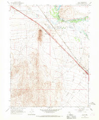 1965 Valmy1967 Print · USGSThe Humboldt River corridor in the mid-1960s serves as a busy transit hub where the historic railroad meets the modern interstate. Researchers can trace the layout of Valmy and the surrounding ranching landscape, including Nelson Ranch, Hunter Ranch, and the waters of Stonehouse Spring.3 unique versions available
End of results
Showing maps 1-2 of 2
Top cities near Valmy
Frequently asked questions
- What are the different types of historical maps available for Valmy?
- What is the oldest map of Valmy?
- Where can I purchase historical maps of Valmy for my home or office?
- Where can I download high-res historical maps of Valmy?
- Are there historical topographic maps available for Valmy?
- Is there historical aerial imagery available for Valmy?
- Where are historical maps of Valmy sourced from?