1960s Maps of Mina, Nevada
Explore 3 historic maps of Mina from the 1960s. These maps offer a rare glimpse into what life looked like during the 1960s — showing old roads, neighborhoods, homes, and landmarks that have changed or disappeared over time.
Whether you're researching your family's past, planning a metal detecting trip, or studying how Mina's landscape evolved across the 1960s, these high-resolution maps are a powerful tool for exploring the history of this region.
- Focus on a specific era: All maps on this page are from the 1960s, giving you a focused view of this time period.
- See what’s changed: Compare century-old streets, trails, and buildings to today's modern landscape using overlays and satellite layers.
- Research with precision: Use these maps for genealogy, historical research, land use analysis, or educational projects.
- View, download, or print: Maps are fully viewable online in high resolution, and can be downloaded or printed for your own records.
Start exploring Mina's history through authentic maps from the 1960s. This is your window into the past.
Mina, NV maps
(3)- 1962 Map of Walker Lake
 1962 Walker Lake1962 Print · USGSThe high desert of western Nevada and the Sierra Nevada crest meet in this mid-century study of the Eastern Sierra frontier. Researchers can trace the Southern Pacific rail lines connecting Hawthorne to remote mining outposts like Bodie, Aurora, and Mina.
 - 1964 Map of Walker Lake
 1964 Walker Lake1964 Print · USGSThe high desert and the Sierra Nevada peaks come together in the mid-1960s, showing a landscape defined by mining, military installations, and vast wilderness. Genealogists and historians can trace the remnants of old mining camps at Bodie or Candelaria and follow the Southern Pacific rail lines.2 unique versions available
 - 1967 Map of Mina, 1970 Print
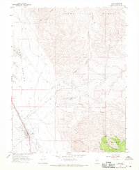 1967 Mina1970 Print · USGSMineral County, Nevada, centers on the rail stop of Mina in the late sixties. Genealogists and historians can trace the town's footprint from Mina Cemetery to the industrial legacy of the Nun Mine and the Old Railroad Grade.2 unique versions available
End of results
Showing maps 1-3 of 3
Frequently asked questions
- What are the different types of historical maps available for Mina?
- What is the oldest map of Mina?
- Where can I purchase historical maps of Mina for my home or office?
- Where can I download high-res historical maps of Mina?
- Are there historical topographic maps available for Mina?
- Is there historical aerial imagery available for Mina?
- Where are historical maps of Mina sourced from?