1980s Maps of Walker Lake, Nevada
Explore 2 historic maps of Walker Lake from the 1980s. These maps offer a rare glimpse into what life looked like during the 1980s — showing old roads, neighborhoods, homes, and landmarks that have changed or disappeared over time.
Whether you're researching your family's past, planning a metal detecting trip, or studying how Walker Lake's landscape evolved across the 1980s, these high-resolution maps are a powerful tool for exploring the history of this region.
- Focus on a specific era: All maps on this page are from the 1980s, giving you a focused view of this time period.
- See what’s changed: Compare century-old streets, trails, and buildings to today's modern landscape using overlays and satellite layers.
- Research with precision: Use these maps for genealogy, historical research, land use analysis, or educational projects.
- View, download, or print: Maps are fully viewable online in high resolution, and can be downloaded or printed for your own records.
Start exploring Walker Lake's history through authentic maps from the 1980s. This is your window into the past.
Walker Lake, NV maps
(2)- 1985 Map of Walker Lake
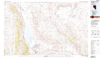 1985 Walker Lake1985 Print · USGSMineral County in the mid-1980s reveals a unique landscape of military expansion and high-desert settlement. Researchers can trace the massive Hawthorne Ammunition Depot, find old mining sites like the Rita Mine, and locate the Southern Pacific rail line.2 unique versions available
 - 1988 Map of Copper Canyon, 1989 Print
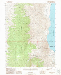 1988 Copper Canyon1989 Print · USGSThe western shore of Walker Lake in the late eighties reveals the massive footprint of the Hawthorne Army Ammunition Plant. Researchers can trace old mountain routes like the Pack Trail or locate remote watering holes such as Wild Horse Spring and Chipmunk Spring.
End of results
Showing maps 1-2 of 2
Top cities near Walker Lake
Frequently asked questions
- What are the different types of historical maps available for Walker Lake?
- What is the oldest map of Walker Lake?
- Where can I purchase historical maps of Walker Lake for my home or office?
- Where can I download high-res historical maps of Walker Lake?
- Are there historical topographic maps available for Walker Lake?
- Is there historical aerial imagery available for Walker Lake?
- Where are historical maps of Walker Lake sourced from?