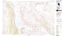
1985 Map of Walker Lake
USGS Topo · Published 1985About this map
Hawthorne Ammunition Depot dominates the southern landscape of this 1985 survey, its grid-like structure of bunkers and roads contrasting with the terminal basin of Walker Lake. The map illustrates a complex intersection of military, tribal, and mining interests during the mid-1980s. To the north, the Walker River Indian Reservation surrounds the settlement of Schurz, where the Walker River enters the lake. The high peaks of the Wassuk Range, including Mt Grant, tower over the western shoreline, while the Southern Pacific railroad tracks trace the industrial corridor through Hawthorne and toward Luning. This period of the Nevada desert is marked by isolated resource extraction sites like the Northern Lights Mine and Gundaker Mill, positioned in the arid reaches between Gabbs Valley and the Garfield Hills.
Find a feature on this map
44 named features on this map. Tap any name to fly to it.
Don’t see what you’re looking for? This feature index may not catch every label — zoom into the map to look around manually.
Map Details
Editions of this 1985 Walker Lake Map
2 editions found
Other maps of this area

1891 · Wabuska
USGS Topo · 1:125,000

1891 · Wellington
USGS Topo · 1:125,000

1893 · Wellington
USGS Topo · 1:125,000

1894 · Wabuska
USGS Topo · 1:125,000

1907 · Tonopah
USGS Topo · 1:250,000

1908 · Tonopah
USGS Topo · 1:250,000

1908 · Carson Sink
USGS Topo · 1:250,000

1909 · Hawthorne
USGS Topo · 1:250,000

1909 · Bridgeport
USGS Topo · 1:125,000

1910 · Carson Sink
USGS Topo · 1:250,000