1940s Maps of Beatty, Nevada
Explore 2 historic maps of Beatty from the 1940s. These maps offer a rare glimpse into what life looked like during the 1940s — showing old roads, neighborhoods, homes, and landmarks that have changed or disappeared over time.
Whether you're researching your family's past, planning a metal detecting trip, or studying how Beatty's landscape evolved across the 1940s, these high-resolution maps are a powerful tool for exploring the history of this region.
- Focus on a specific era: All maps on this page are from the 1940s, giving you a focused view of this time period.
- See what’s changed: Compare century-old streets, trails, and buildings to today's modern landscape using overlays and satellite layers.
- Research with precision: Use these maps for genealogy, historical research, land use analysis, or educational projects.
- View, download, or print: Maps are fully viewable online in high resolution, and can be downloaded or printed for your own records.
Start exploring Beatty's history through authentic maps from the 1940s. This is your window into the past.
Beatty, NV maps
(2)- 1942 Map of Bullfrog
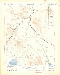 1942 Bullfrog1942 Print · USGSThe high desert of southern Nevada and eastern California is shown here during the early war years, documenting the region's mining and railroad legacy. Researchers can trace the T & T (Abandoned) railroad grade and locate mining sites like Jumbo and Ladd near Rhyolite.
 - 1948 Map of Death Valley
 1948 Death Valley1948 Print · USGSIn the late 1940s, this desert frontier was defined by isolated mining camps and military restricted zones. Researchers can trace the routes between Furnace Creek Ranch and Rhyolite, or locate remote sites like the Modoc Mine and Ballarat.2 unique versions available
End of results
Showing maps 1-2 of 2
Frequently asked questions
- What are the different types of historical maps available for Beatty?
- What is the oldest map of Beatty?
- Where can I purchase historical maps of Beatty for my home or office?
- Where can I download high-res historical maps of Beatty?
- Are there historical topographic maps available for Beatty?
- Is there historical aerial imagery available for Beatty?
- Where are historical maps of Beatty sourced from?