1900s (20th Century) Maps of Currant, Nevada
Explore 5 historic maps of Currant from the 1900s (20th Century). These maps offer a rare glimpse into what life looked like during the 1900s — showing old roads, neighborhoods, homes, and landmarks that have changed or disappeared over time.
Whether you're researching your family's past, planning a metal detecting trip, or studying how Currant's landscape evolved across the 1900s, these high-resolution maps are a powerful tool for exploring the history of this region.
- Focus on a specific era: All maps on this page are from the 1900s, giving you a focused view of this time period.
- See what’s changed: Compare century-old streets, trails, and buildings to today's modern landscape using overlays and satellite layers.
- Research with precision: Use these maps for genealogy, historical research, land use analysis, or educational projects.
- View, download, or print: Maps are fully viewable online in high resolution, and can be downloaded or printed for your own records.
Start exploring Currant's history through authentic maps from the 1900s. This is your window into the past.
Currant, NV maps
(5)- 1956 Map of Lund, 1963 Print
 1956 Lund1963 Print · USGSEastern Nevada and the Utah borderlands are mapped here during the mid-fifties, showing a landscape of high-desert ranches and mountain mining camps. Genealogists and historians can trace family locations through sites like Bristol Silver Mines, Lund, and the Sunnyside Whipple Ranch.2 unique versions available
 - 1960 Map of Lund
 1960 Lund1960 Print · USGSEastern Nevada and the Utah borderlands are mapped here during the mid-twentieth century, showing a landscape of high peaks and isolated ranching outposts. Researchers can locate remote mining sites like the Tungsten Queen Mine and early settlements including Lund and Shoshone.
 - 1964 Map of Currant, 1965 Print
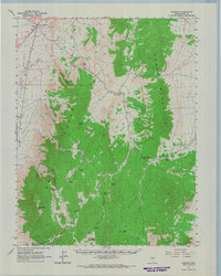 1964 Currant1965 Print · USGSNye County ranching and mining life is documented here in the early sixties as it centered around Currant. Researchers can find isolated landmarks like the Stone Cabin, El Padre Mine, and a lonely Grave along the base of the Grant Range.
 - 1980 Map of Duckwater, 1981 Print
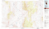 1980 Duckwater1981 Print · USGSNye County and White Pine County are shown here in the early eighties as a landscape of isolated valleys and high mountain ranges. Genealogists and researchers can trace remote settlements like Duckwater, locate the Gold Point Mine, or find the unique Meteorite Crater.2 unique versions available
 - 1990 Map of Currant
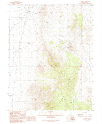 1990 Currant1990 Print · USGSNye County ranching and mining operations are captured here during the late twentieth century. Researchers can locate remote industrial sites like El Padre Mine alongside humble landmarks such as a solitary Grave and the Blue Eagle Well.
End of results
Showing maps 1-5 of 5
Frequently asked questions
- What are the different types of historical maps available for Currant?
- What is the oldest map of Currant?
- Where can I purchase historical maps of Currant for my home or office?
- Where can I download high-res historical maps of Currant?
- Are there historical topographic maps available for Currant?
- Is there historical aerial imagery available for Currant?
- Where are historical maps of Currant sourced from?