1950s Maps of North Gabbs, Nye County
Explore 3 historic maps of North Gabbs from the 1950s. These maps offer a rare glimpse into what life looked like during the 1950s — showing old roads, neighborhoods, homes, and landmarks that have changed or disappeared over time.
Whether you're researching your family's past, planning a metal detecting trip, or studying how North Gabbs's landscape evolved across the 1950s, these high-resolution maps are a powerful tool for exploring the history of this region.
- Focus on a specific era: All maps on this page are from the 1950s, giving you a focused view of this time period.
- See what’s changed: Compare century-old streets, trails, and buildings to today's modern landscape using overlays and satellite layers.
- Research with precision: Use these maps for genealogy, historical research, land use analysis, or educational projects.
- View, download, or print: Maps are fully viewable online in high resolution, and can be downloaded or printed for your own records.
Start exploring North Gabbs's history through authentic maps from the 1950s. This is your window into the past.
North Gabbs, Nye County maps
(3)- 1950 Map of Paradise Peak
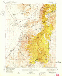 1950 Paradise Peak1950 Print · USGSMid-century mining operations dominate this Nye County landscape as industrial magnesite and tungsten extraction centers around Brucite. Local historians can trace the foundations of Downeyville or the active Illinois Mine and Paradise Mine.
 - 1956 Map of Tonopah, 1974 Print
 1956 Tonopah1974 Print · USGSCentral Nevada in the mid-fifties reveals a landscape shaped by mining and military footprints. Trace old silver districts near Tonopah and Manhattan, or locate early industrial sites like the Borax works at Columbus Salt Marsh.2 unique versions available
 - 1959 Map of Tonopah
 1959 Tonopah1959 Print · USGSCentral Nevada in the late fifties is a landscape of high desert ranges and mining history. Trace the remnants of old boomtowns and industrial sites like Berlin, the Gold Hill Mill, and the Victory Tungsten Mine.2 unique versions available
End of results
Showing maps 1-3 of 3
Frequently asked questions
- What are the different types of historical maps available for North Gabbs?
- What is the oldest map of North Gabbs?
- Where can I purchase historical maps of North Gabbs for my home or office?
- Where can I download high-res historical maps of North Gabbs?
- Are there historical topographic maps available for North Gabbs?
- Is there historical aerial imagery available for North Gabbs?
- Where are historical maps of North Gabbs sourced from?