1960s Maps of Reveille, Nevada
Explore 3 historic maps of Reveille from the 1960s. These maps offer a rare glimpse into what life looked like during the 1960s — showing old roads, neighborhoods, homes, and landmarks that have changed or disappeared over time.
Whether you're researching your family's past, planning a metal detecting trip, or studying how Reveille's landscape evolved across the 1960s, these high-resolution maps are a powerful tool for exploring the history of this region.
- Focus on a specific era: All maps on this page are from the 1960s, giving you a focused view of this time period.
- See what’s changed: Compare century-old streets, trails, and buildings to today's modern landscape using overlays and satellite layers.
- Research with precision: Use these maps for genealogy, historical research, land use analysis, or educational projects.
- View, download, or print: Maps are fully viewable online in high resolution, and can be downloaded or printed for your own records.
Start exploring Reveille's history through authentic maps from the 1960s. This is your window into the past.
Reveille, NV maps
(3)- 1962 Map of Tonopah
 1962 Tonopah1962 Print · USGSCentral Nevada's high desert mining country is captured here during the early sixties, showing the enduring footprint of the silver and gold rushes. Researchers can trace the decline of historic camps and locate industrial sites like the Tybo Mine, Victory Tungsten Mine, and the Mt. Moriah Cemetery.2 unique versions available
 - 1968 Map of Reveille, 1971 Print
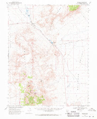 1968 Reveille1971 Print · USGSNye County's high desert mining landscape is captured in the late sixties as the era of traditional extraction met modern surveying. Researchers can trace the footprints of the New Reveille Mine, locate the Reveille (Site) and its cemetery, and follow the path of Nyala Road.2 unique versions available
 - 1968 Map of Reveille, 1973 Print
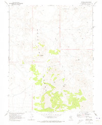 1968 Reveille1973 Print · USGSNye County’s mining heart is captured in the late sixties, showcasing the high-altitude workings of the Reveille Range. Researchers can trace old prospects and settlements including Reveille, the Lost Burro Mine, and Hyde Spring.2 unique versions available
End of results
Showing maps 1-3 of 3
Frequently asked questions
- What are the different types of historical maps available for Reveille?
- What is the oldest map of Reveille?
- Where can I purchase historical maps of Reveille for my home or office?
- Where can I download high-res historical maps of Reveille?
- Are there historical topographic maps available for Reveille?
- Is there historical aerial imagery available for Reveille?
- Where are historical maps of Reveille sourced from?