
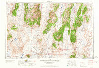
1962 Map of Tonopah
USGS Topo · Published 1962About this map
Tonopah serves as the focal point for this mid-century survey of the Central Nevada basin and range, an area defined by its deep mining heritage and stark desert basins. The map documents a landscape transitioning from the frantic silver and gold booms of earlier decades to a more industrial footing, featuring numerous sites like the Warrior Mine and the Gold Hill Mill. Settlement patterns follow the valley floors, with towns like Manhattan, Round Mountain, and the once-prominent county seat of Belmont standing as markers of the region's mineral wealth. Genealogists can locate specific burial sites at Mt. Moriah Cemetery and the Tonopah Cem. The topography is dominated by the massive north-south cordilleras of the Toiyabe Range and Monitor Range, while the lower elevations contain the expansive Columbus Salt Marsh and the arid reaches of Big Smoky Valley.
Find a feature on this map
77 named features on this map. Tap any name to fly to it.
Don’t see what you’re looking for? This feature index may not catch every label — zoom into the map to look around manually.
Map Details
Editions of this 1962 Tonopah Map
2 editions found
Other maps of this area

1898 · Silver Peak
USGS Topo · 1:125,000

1900 · Silver Peak
USGS Topo · 1:125,000

1907 · Tonopah
USGS Topo · 1:250,000

1908 · Kawich
USGS Topo · 1:250,000

1908 · Lida
USGS Topo · 1:250,000

1908 · Tonopah
USGS Topo · 1:250,000

1908 · Carson Sink
USGS Topo · 1:250,000

1909 · Hawthorne
USGS Topo · 1:250,000

1910 · Carson Sink
USGS Topo · 1:250,000

1911 · Hawthorne
USGS Topo · 1:250,000