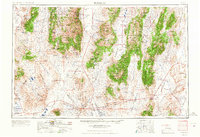
1962 Map of Tonopah
USGS Topo · Published 1967About this map
Tonopah serves as the focal point of this high-desert survey, where the mining legacy of the central Nevada ranges is clearly visible. The landscape is defined by massive north-south depressions like Big Smoky Valley and Ralston Valley, separated by the heights of the Toiyabe Range and Monitor Range. Local history is preserved in the location of numerous mining sites and fading settlements, including Belmont and Gilbert, which were once thriving hubs of silver and tungsten extraction.
Find a feature on this map
61 named features on this map. Tap any name to fly to it.
Don’t see what you’re looking for? This feature index may not catch every label — zoom into the map to look around manually.
Map Details
Editions of this 1962 Tonopah Map
2 editions found

Other maps of this area

1898 · Silver Peak
USGS Topo · 1:125,000

1900 · Silver Peak
USGS Topo · 1:125,000

1907 · Tonopah
USGS Topo · 1:250,000

1908 · Kawich
USGS Topo · 1:250,000

1908 · Lida
USGS Topo · 1:250,000

1908 · Tonopah
USGS Topo · 1:250,000

1908 · Carson Sink
USGS Topo · 1:250,000

1909 · Hawthorne
USGS Topo · 1:250,000

1910 · Carson Sink
USGS Topo · 1:250,000

1911 · Hawthorne
USGS Topo · 1:250,000