
1908 Map of Kawich
USGS Topo · Published 1908About this map
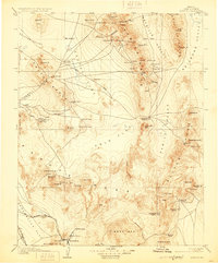
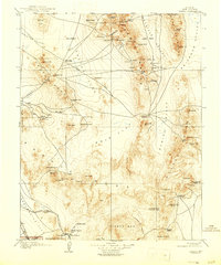
Longstreets Ranch and Eden anchor the northern reaches of this high-desert landscape, captured during a period of intense mining speculation in Nye County. The map documents the rapid expansion of camps and post offices like Gold Reed Kawich PO, Silverbow, and Golden Arrow following early 20th-century mineral discoveries. This survey illustrates a primitive transportation network where an early Auto Road snakes across Cactus Flat, connecting isolated outposts with more established water sources like Antelope Sprs and Cactus Spr.
Find a feature on this map
89 named features on this map. Tap any name to fly to it.
Don’t see what you’re looking for? This feature index may not catch every label — zoom into the map to look around manually.
Map Details
Editions of this 1908 Kawich Map
3 editions found
Other maps of this area

1907 · Tonopah
USGS Topo · 1:250,000

1907 · Las Vegas
USGS Topo · 1:250,000

1908 · Lida
USGS Topo · 1:250,000

1908 · Furnace Creek
USGS Topo · 1:250,000

1908 · Las Vegas
USGS Topo · 1:250,000

1908 · Tonopah
USGS Topo · 1:250,000

1908 · Ballarat
USGS Topo · 1:250,000

1910 · Furnace Creek
USGS Topo · 1:250,000

1913 · Lida
USGS Topo · 1:250,000

1913 · Ballarat
USGS Topo · 1:250,000