1908 Map of Kawich
USGS Topo · Published 1929About this map
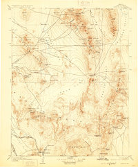
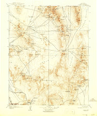
Kawich Range and the high desert basins of southern Nye County are captured here during a pivotal era of mining prospecting in the early 1900s. The landscape is a network of ephemeral camps and vital water sources, with settlements like Silverbow, Golden Arrow, and Gold Reed Kawich PO marking the transient centers of local industry. These remote outposts were connected by early transit routes, including the Goldfield RR and a designated Auto Road cutting across Cactus Flat.
Find a feature on this map
87 named features on this map. Tap any name to fly to it.
Don’t see what you’re looking for? This feature index may not catch every label — zoom into the map to look around manually.
Map Details
Editions of this 1908 Kawich Map
3 editions found
Other maps of this area

1907 · Tonopah
USGS Topo · 1:250,000

1907 · Las Vegas
USGS Topo · 1:250,000

1908 · Kawich
USGS Topo · 1:250,000

1908 · Lida
USGS Topo · 1:250,000

1908 · Furnace Creek
USGS Topo · 1:250,000

1908 · Las Vegas
USGS Topo · 1:250,000

1908 · Tonopah
USGS Topo · 1:250,000

1908 · Ballarat
USGS Topo · 1:250,000

1910 · Furnace Creek
USGS Topo · 1:250,000

1913 · Lida
USGS Topo · 1:250,000