1980s Maps of South Gabbs, Nye County
Explore 2 historic maps of South Gabbs from the 1980s. These maps offer a rare glimpse into what life looked like during the 1980s — showing old roads, neighborhoods, homes, and landmarks that have changed or disappeared over time.
Whether you're researching your family's past, planning a metal detecting trip, or studying how South Gabbs's landscape evolved across the 1980s, these high-resolution maps are a powerful tool for exploring the history of this region.
- Focus on a specific era: All maps on this page are from the 1980s, giving you a focused view of this time period.
- See what’s changed: Compare century-old streets, trails, and buildings to today's modern landscape using overlays and satellite layers.
- Research with precision: Use these maps for genealogy, historical research, land use analysis, or educational projects.
- View, download, or print: Maps are fully viewable online in high resolution, and can be downloaded or printed for your own records.
Start exploring South Gabbs's history through authentic maps from the 1980s. This is your window into the past.
South Gabbs, Nye County maps
(2)- 1985 Map of Ione Valley
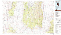 1985 Ione Valley1985 Print · USGSCentral Nevada in the mid-eighties was a landscape of high desert basins and legendary mining districts. Genealogists and historians can trace the foundations of Round Mountain, the operations of the Manhattan Dredge, and the locations of remote sites like Grantsville and Ione.2 unique versions available
 - 1988 Map of Gabbs
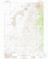 1988 Gabbs1988 Print · USGSGabbs and the surrounding Paradise Range mining districts are captured here in the late 1980s. Genealogists and industrial historians can trace active and former operations like the Sierra Mine, the Brucite site, and the Lucky Strike Mine.
End of results
Showing maps 1-2 of 2
Frequently asked questions
- What are the different types of historical maps available for South Gabbs?
- What is the oldest map of South Gabbs?
- Where can I purchase historical maps of South Gabbs for my home or office?
- Where can I download high-res historical maps of South Gabbs?
- Are there historical topographic maps available for South Gabbs?
- Is there historical aerial imagery available for South Gabbs?
- Where are historical maps of South Gabbs sourced from?