1960s Maps of Bonnie Briar, Nevada
Explore 2 historic maps of Bonnie Briar from the 1960s. These maps offer a rare glimpse into what life looked like during the 1960s — showing old roads, neighborhoods, homes, and landmarks that have changed or disappeared over time.
Whether you're researching your family's past, planning a metal detecting trip, or studying how Bonnie Briar's landscape evolved across the 1960s, these high-resolution maps are a powerful tool for exploring the history of this region.
- Focus on a specific era: All maps on this page are from the 1960s, giving you a focused view of this time period.
- See what’s changed: Compare century-old streets, trails, and buildings to today's modern landscape using overlays and satellite layers.
- Research with precision: Use these maps for genealogy, historical research, land use analysis, or educational projects.
- View, download, or print: Maps are fully viewable online in high resolution, and can be downloaded or printed for your own records.
Start exploring Bonnie Briar's history through authentic maps from the 1960s. This is your window into the past.
Bonnie Briar, NV maps
(2)- 1961 Map of Dun Glen, 1963 Print
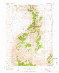 1961 Dun Glen1963 Print · USGSPershing County's mining and ranching heritage is captured here in the early 1960s, showing the rugged East Range and its high-desert outposts. Researchers can trace historic workings at the Black Hole Mine or locate early settlements like Dun Glen and the Grass Valley Ranch.3 unique versions available
 - 1962 Map of Winnemucca
 1962 Winnemucca1962 Print · USGSNorthern Nevada's high desert comes alive in the mid-1950s as a vital transportation and mining corridor following the Humboldt River. Trace the early rail-and-ranch economy through stops like Palisade, find old workings at the Adelaide Mine, and see the layout of Winnemucca before the interstate era.
End of results
Showing maps 1-2 of 2
Frequently asked questions
- What are the different types of historical maps available for Bonnie Briar?
- What is the oldest map of Bonnie Briar?
- Where can I purchase historical maps of Bonnie Briar for my home or office?
- Where can I download high-res historical maps of Bonnie Briar?
- Are there historical topographic maps available for Bonnie Briar?
- Is there historical aerial imagery available for Bonnie Briar?
- Where are historical maps of Bonnie Briar sourced from?