1980s Maps of Baker, Nevada
Explore 2 historic maps of Baker from the 1980s. These maps offer a rare glimpse into what life looked like during the 1980s — showing old roads, neighborhoods, homes, and landmarks that have changed or disappeared over time.
Whether you're researching your family's past, planning a metal detecting trip, or studying how Baker's landscape evolved across the 1980s, these high-resolution maps are a powerful tool for exploring the history of this region.
- Focus on a specific era: All maps on this page are from the 1980s, giving you a focused view of this time period.
- See what’s changed: Compare century-old streets, trails, and buildings to today's modern landscape using overlays and satellite layers.
- Research with precision: Use these maps for genealogy, historical research, land use analysis, or educational projects.
- View, download, or print: Maps are fully viewable online in high resolution, and can be downloaded or printed for your own records.
Start exploring Baker's history through authentic maps from the 1980s. This is your window into the past.
Baker, NV maps
(2)- 1986 Map of Baker
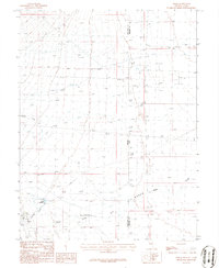 1986 Baker1986 Print · USGSThe Nevada-Utah borderlands near the settlement of Baker are documented here in the mid-1980s. Local historians and researchers can trace water usage through the Baker Reservoir and Ditch networks or locate the Landing strip and Trailer Park.2 unique versions available
 - 1987 Map of Ely
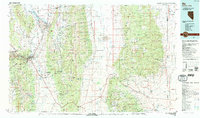 1987 Ely1987 Print · USGSWhite Pine County's high-desert mining and rail landscape is shown here in the late eighties. Researchers can trace the massive Ruth Pit copper mines, the Nevada Northern RR, and early settlements like Osceola and Lane City.2 unique versions available
End of results
Showing maps 1-2 of 2
Frequently asked questions
- What are the different types of historical maps available for Baker?
- What is the oldest map of Baker?
- Where can I purchase historical maps of Baker for my home or office?
- Where can I download high-res historical maps of Baker?
- Are there historical topographic maps available for Baker?
- Is there historical aerial imagery available for Baker?
- Where are historical maps of Baker sourced from?