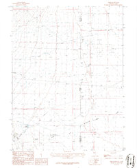
1986 Map of Baker
USGS Topo · Published 1986About this map
The small Nevada community of Baker serves as the focal point of this 1980s landscape, positioned near the base of the mountains where several alpine drainages descend toward the desert floor. The irrigation and water management patterns of the era are clearly visible through a network of Ditch lines and the presence of Baker Reservoir, which capture the flow of perennial streams like Lehman Creek and Silver Creek. One of the most distinctive geological features recorded is the Sinks of Baker Creek, where surface water disappears into the subterranean drainage system typical of the Great Basin.
Find a feature on this map
15 named features on this map. Tap any name to fly to it.
Don’t see what you’re looking for? This feature index may not catch every label — zoom into the map to look around manually.
Map Details
Editions of this 1986 Baker Map
2 editions found
Other maps of this area

1908 · Fish Springs
USGS Topo · 1:250,000

1910 · Fish Springs
USGS Topo · 1:250,000

1949 · Garrison
USGS Topo · 1:62,500

1951 · Garrison
USGS Topo · 1:62,500

1953 · Richfield
USGS Topo · 1:250,000

1953 · Delta
USGS Topo · 1:250,000

1956 · Lund
USGS Topo · 1:250,000

1956 · Ely
USGS Topo · 1:250,000

1958 · Richfield
USGS Topo · 1:250,000

1958 · Delta
USGS Topo · 1:250,000