1950s Maps of Ely, Nevada
Explore 9 historic maps of Ely from the 1950s. These maps offer a rare glimpse into what life looked like during the 1950s — showing old roads, neighborhoods, homes, and landmarks that have changed or disappeared over time.
Whether you're researching your family's past, planning a metal detecting trip, or studying how Ely's landscape evolved across the 1950s, these high-resolution maps are a powerful tool for exploring the history of this region.
- Focus on a specific era: All maps on this page are from the 1950s, giving you a focused view of this time period.
- See what’s changed: Compare century-old streets, trails, and buildings to today's modern landscape using overlays and satellite layers.
- Research with precision: Use these maps for genealogy, historical research, land use analysis, or educational projects.
- View, download, or print: Maps are fully viewable online in high resolution, and can be downloaded or printed for your own records.
Start exploring Ely's history through authentic maps from the 1950s. This is your window into the past.
Ely, NV maps
(9)- 1952 Map of Ely, 1954 Print
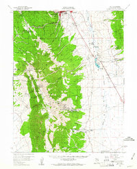
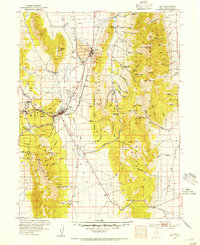 1952 Ely1954 Print · USGSCentral Nevada's mining heartland is captured here during the mid-fifties copper boom. Genealogists and historians can trace the Nevada Northern RR between the copper pits of Ruth and the industrial infrastructure of McGill and East Ely.3 unique versions available
 - 1956 Map of Ely, 1968 Print
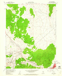
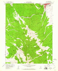
 1956 Ely1968 Print · USGSEastern Nevada in the mid-fifties is a land of massive mountain ranges and silver-boom history. Trace the legacy of mining ruins at Hamilton and Treasure City or follow the path of the Nevada Northern RR through Ely.5 unique versions available
 - 1958 Map of Ruth, 1960 Print
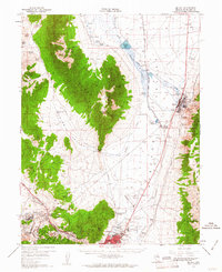
 1958 Ruth1960 Print · USGSMining operations in the Egan Range were at their peak during the late fifties, transforming the landscape around Ruth. Researchers can trace the extensive rail network of the Nevada Northern and locate historic shafts like the Elijah Mine or Ada Shaft.3 unique versions available
 - 1958 Map of East Ely, 1961 Print
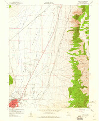 1958 East Ely1961 Print · USGSEast Ely and the surrounding Steptoe Valley are captured here in the late fifties, showcasing a landscape defined by rail and early aviation. Researchers can trace the Nevada Northern railroad, locate the Baltimore Mill, and see the footprint of Yelland Field.2 unique versions available
 - 1958 Map of Comins Lake, 1961 Print
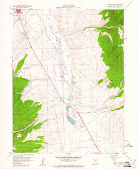 1958 Comins Lake1961 Print · USGSWhite Pine County in the late fifties reveals a landscape shaped by high-desert mining and valley ranching. Genealogists and industrial historians can trace specific operations like the Joe Shaft, the Monitor Mill (Site), and the CCC Ranch.4 unique versions available
 - 1958 Map of Ely, 1961 Print
 1958 Ely1961 Print · USGSThe high desert of eastern Nevada comes alive in this mid-century survey of the Egan Range and the thriving hub of Ely. Genealogists and industrial historians can trace the Nevada Northern RR, the Ward townsite, and the Young American Graves.2 unique versions available
 - 1958 Map of McGill, 1961 Print
 1958 McGill1961 Print · USGSWhite Pine County’s copper industrial complex and valley ranching are fully established in this late-fifties topographic record. Researchers can trace the Nevada Northern Railway corridor from McGill to East Ely and locate landmarks like Yelland Field and Lusetti Ranch.2 unique versions available
 - 1958 Map of Ely, 1961 Print
 1958 Ely1961 Print · USGSMining operations and mountain recreation converged at Ely during the late fifties, where the Egan Range rises sharply from the high desert floor. Local history buffs can trace the locations of the Farnsworth-Ely Metal Mine and the original Ward Mtn Ski Hill as they appeared decades ago.5 unique versions available
 - 1959 Map of Ely
 1959 Ely1959 Print · USGSEastern Nevada's high desert reveals its mining heart and pioneer ranching outposts during the late fifties. Genealogists and historians can trace family-named outposts like Goicoechea Ranch or explore the ruins of former silver-mining hubs like Hamilton and Treasure City.2 unique versions available
End of results
Showing maps 1-9 of 9
Top cities near Ely
Top neighborhoods of Ely
Frequently asked questions
- What are the different types of historical maps available for Ely?
- What is the oldest map of Ely?
- Where can I purchase historical maps of Ely for my home or office?
- Where can I download high-res historical maps of Ely?
- Are there historical topographic maps available for Ely?
- Is there historical aerial imagery available for Ely?
- Where are historical maps of Ely sourced from?