1980s Maps of Belknap County, New Hampshire
Explore 21 historic maps of Belknap County from the 1980s. These maps offer a rare glimpse into what life looked like during the 1980s — showing old roads, neighborhoods, homes, and landmarks that have changed or disappeared over time.
Whether you're researching your family's past, planning a metal detecting trip, or studying how Belknap County's landscape evolved across the 1980s, these high-resolution maps are a powerful tool for exploring the history of this region.
- Focus on a specific era: All maps on this page are from the 1980s, giving you a focused view of this time period.
- See what’s changed: Compare century-old streets, trails, and buildings to today's modern landscape using overlays and satellite layers.
- Research with precision: Use these maps for genealogy, historical research, land use analysis, or educational projects.
- View, download, or print: Maps are fully viewable online in high resolution, and can be downloaded or printed for your own records.
Start exploring Belknap County's history through authentic maps from the 1980s. This is your window into the past.
Belknap County, NH maps
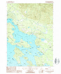
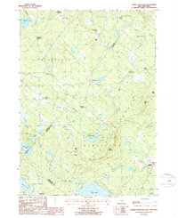
(21)- 1980 Map of Squam Mountains, 1981 Print
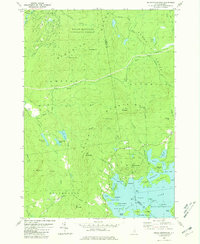 1980 Squam Mountains1981 Print · USGSThe Squam Lake shoreline and high peaks of the Sandwich Range define this central New Hampshire landscape in the early eighties. Genealogists and hikers can trace historical routes like the Sandwich Notch Road, the Old RR Grade, and localized landmarks including the Covered Bridge.2 unique versions available
 - 1986 Map of Lake Winnipesaukee
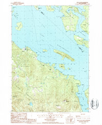
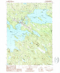
 1986 Lake Winnipesaukee1986 Print · USGSThe Lakes Region in the mid-eighties shows a landscape of dense water bodies and mountain ranges at the peak of its twentieth-century character. Trace the legacy of old rail lines like the Boston and Maine RR and locate historic centers from Rumney Depot to Melvin Village.2 unique versions available
 - 1986 Map of Concord
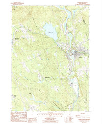
 1986 Concord1986 Print · USGSCentral New Hampshire in the mid-eighties shows a landscape of river-valley cities and rural villages connected by the growing interstate system. Genealogists and historians can trace old community centers like Gilmanton Ironworks or follow the Boston and Maine Railroad through Concord and Tilton.
 - 1987 Map of Winnisquam Lake
 1987 Winnisquam Lake1987 Print · USGSThe Lakes Region of New Hampshire appears here in the late twentieth century, showing a landscape of interconnected basins and protected woodlands. Genealogists and local researchers can trace family landmarks near Meredith Center, Gaza, and the Bay Meetinghouse.
 - 1987 Map of Holderness
 1987 Holderness1987 Print · USGSThe Lakes Region at the close of the twentieth century shows a landscape of interconnected waters and rising hills. Genealogists and local historians can trace family landmarks like Dolloff Hill, rural Cem sites, and the extent of Sky Pond State Forest.
 - 1987 Map of Alton
 1987 Alton1987 Print · USGSThe southeastern shore of Lake Winnipesaukee comes alive in the late eighties, showing the transition from lakeside recreation to permanent residential growth. Genealogists can trace family lines through Stockbridge Corners and New Durham Corner, while local historians can locate the Fish Hatchery and Alton Bay State Forest.2 unique versions available
 - 1987 Map of Bristol
 1987 Bristol1987 Print · USGSCentral New Hampshire in the late eighties reveals a landscape of river valleys and timbered peaks across Grafton and Belknap counties. Genealogists and hikers can trace family-named landmarks like Huses Mountain or explore Sugar Hill State Forest and New Hampton.
 - 1987 Map of West Alton
 1987 West Alton1987 Print · USGSLake Winnipesaukee's southern reaches were well-defined by the late twentieth century, showing a mix of established summer camps and mountain preserves. Researchers can trace land ownership and community layout around West Alton, Sandy Island Camp, and the historic Mt Washington Boat Route.2 unique versions available
 - 1987 Map of Pittsfield
 1987 Pittsfield1987 Print · USGSMerrimack County comes into focus in the late 1980s as the Suncook River flows through the industrial hub of Pittsfield. Genealogists and local historians can trace the Old Railroad Grade or locate family landmarks like Websters Mill and Sanborn Hill.
 - 1987 Map of Franklin
 1987 Franklin1987 Print · USGSMerrimack County at the end of the 1980s shows a landscape defined by its famous river forks and the legacy of its early statesmen. Genealogists and historians can trace family-named sites from Webster Place to the Daniel Webster Birthplace, while mapping the development around Webster Lake and Franklin.
 - 1987 Map of Belmont
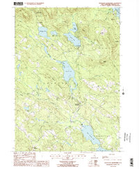
 1987 Belmont1987 Print · USGSBelknap County at the close of the eighties shows a landscape of deep forests and quiet mill towns. Genealogists and local historians can trace family-named sites like Aliens Mills, Jones Mills, and the heights of Loudon Ridge.
 - 1987 Map of Laconia
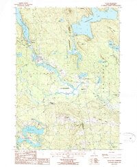
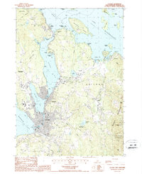 1987 Laconia1987 Print · USGSBelknap County's lakefront communities and recreation centers are captured here during the late eighties. Researchers can trace the development of the Laconia waterfront, find landmarks like the Drive-In Theater, or explore the slopes of Gunstock Mtn.2 unique versions available
 - 1987 Map of Center Harbor
 1987 Center Harbor1987 Print · USGSThe northern waters of Lake Winnipesaukee meet the heights of Red Hill in the late eighties. Genealogists and local historians can trace the lakeside docks of Center Harbor, the cemetery at Sunset Hill, and the scattered islands from Bear Island to Jolly Island.
 - 1987 Map of Melvin Village
 1987 Melvin Village1987 Print · USGSLake Winnipesaukee's northern shores are captured in the late eighties, showing a landscape defined by historic landings and the transition into the Ossipee Mountains. Genealogists and local historians can trace family locations near Melvin Village, Center Tuftonboro, and the working waterfront at Union Wharf.
 - 1987 Map of Northfield
 1987 Northfield1987 Print · USGSThe twin towns of Tilton and Northfield straddle the river in the late 1980s, showing a landscape shaped by water and industry. Researchers can trace historic property lines near Ayers State Forest or locate early settlements like Sanbornton and Lochmere.
 - 1987 Map of Ashland
 1987 Ashland1987 Print · USGSGrafton and Belknap counties come together along the Pemigewasset River in the late 1980s, showcasing a landscape of high peaks and winding brooks. Researchers can trace the boundaries of the Scribner-Fellows State Forest or locate early landmarks like Dick Brown Pond and Hicks Hill.
 - 1987 Map of Loudon
 1987 Loudon1987 Print · USGSMerrimack County in the late 1980s reveals a landscape of enduring village centers and river-fed forests. Researchers can trace the heritage of Shaker Village, locate the waters of Carding Mill Pond, and explore the hills around Loudon Center.2 unique versions available
 - 1987 Map of Gilmanton Ironworks
 1987 Gilmanton Ironworks1987 Print · USGSBelknap County, New Hampshire, is captured in the late twentieth century as its lakeside communities and mountain forests thrived. Genealogists and local historians can trace the areas around Gilmanton Ironworks, the shores of Crystal Lake, and family-named landmarks like Halls Hill.2 unique versions available
 - 1987 Map of Parker Mountain
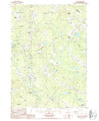
 1987 Parker Mountain1987 Print · USGSThe rural hills of Strafford and Barnstead are captured here in the late twentieth century, showing a landscape defined by traditional family-named crossroads. Researchers can locate historic burial sites at several mapped cemeteries or trace the geography of old homesteads near Lockes Corner, Shackford Corners, and the shores of Bow Lake.2 unique versions available
 - 1987 Map of Wolfeboro
 1987 Wolfeboro1987 Print · USGSThe Lakes Region of New Hampshire thrives in the late eighties, centered on the bustling resort community of Wolfeboro. Genealogists and historians can trace family-named landmarks like Cates Hill and Hayes Hill, or explore the shorelines of Lake Winnipesaukee and Lake Wentworth.
 - 1988 Map of Concord
 1988 Concord1988 Print · USGSCentral New Hampshire in the late eighties centers on the industrial and political hub of Concord. Researchers can trace the Boston and Maine RR along the Merrimack River or locate recreation landmarks like Bear Brook State Park and Massabesic Lake.
End of results
Showing maps 1-21 of 21
Top cities of Belknap County
- Laconia historical maps
- Gilford historical maps
- Belmont historical maps
- Barnstead historical maps
- Tilton historical maps
- Gilmanton historical maps
See more
Frequently asked questions
- What are the different types of historical maps available for Belknap County?
- What is the oldest map of Belknap County?
- Where can I purchase historical maps of Belknap County for my home or office?
- Where can I download high-res historical maps of Belknap County?
- Are there historical topographic maps available for Belknap County?
- Is there historical aerial imagery available for Belknap County?
- Where are historical maps of Belknap County sourced from?