1980s Maps of Conway, New Hampshire
Explore 9 historic maps of Conway from the 1980s. These maps offer a rare glimpse into what life looked like during the 1980s — showing old roads, neighborhoods, homes, and landmarks that have changed or disappeared over time.
Whether you're researching your family's past, planning a metal detecting trip, or studying how Conway's landscape evolved across the 1980s, these high-resolution maps are a powerful tool for exploring the history of this region.
- Focus on a specific era: All maps on this page are from the 1980s, giving you a focused view of this time period.
- See what’s changed: Compare century-old streets, trails, and buildings to today's modern landscape using overlays and satellite layers.
- Research with precision: Use these maps for genealogy, historical research, land use analysis, or educational projects.
- View, download, or print: Maps are fully viewable online in high resolution, and can be downloaded or printed for your own records.
Start exploring Conway's history through authentic maps from the 1980s. This is your window into the past.
Conway, NH maps
(9)- 1985 Map of Portland, 1986 Print
 1985 Portland1986 Print · USGSThe Maine coast and Sebago Lake region are captured in the mid-1980s, showcasing the transition from traditional maritime centers to a modern transportation hub. Genealogists and historians can trace rail lines like the Grand Trunk RR and find local landmarks such as the U.S. Marine Hospital or Old Orchard Beach.2 unique versions available
 - 1986 Map of Lake Winnipesaukee
 1986 Lake Winnipesaukee1986 Print · USGSThe Lakes Region in the mid-eighties shows a landscape of dense water bodies and mountain ranges at the peak of its twentieth-century character. Trace the legacy of old rail lines like the Boston and Maine RR and locate historic centers from Rumney Depot to Melvin Village.2 unique versions available
 - 1986 Map of Lewiston
 1986 Lewiston1986 Print · USGSMaine’s industrial river valleys and western mountain foothills are captured here in the mid-eighties as rail and road networks tied the region together. Genealogists and historians can trace the development of mill towns and lakefront settlements from Lisbon to Bethel, following the Androscoggin River and the path of the Maine Central Railroad.2 unique versions available
 - 1986 Map of Mount Washington
 1986 Mount Washington1986 Print · USGSThe northern New England highlands are shown here in the mid-eighties, centered on the high peaks and river valleys of the New Hampshire borderlands. Researchers can trace historic transportation lines like the Mount Washington Cog Railway and the Maine Central Railroad near Gorham and Lancaster.
 - 1987 Map of North Conway East
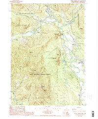
 1987 North Conway East1987 Print · USGSThe borderlands of New Hampshire and Maine are captured here in the late 1980s, centered on the tourism and transit hubs of the Saco River valley. Genealogists and hikers can trace the Maine Central RR through Redstone or locate landmarks like Cranmore Mtn and White Mountain Airport.
 - 1987 Map of Conway
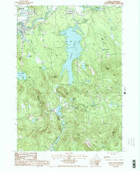 1987 Conway1987 Print · USGSThe Saco River valley and the village of Conway appear here in the late eighties, surrounded by the peaks and ponds of Carroll County. Researchers can locate family cemeteries and trace the shorelines of Conway Lake, Purity Lake, and Crystal Lake near settlements like Snowville.2 unique versions available
 - 1987 Map of North Conway West
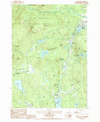
 1987 North Conway West1987 Print · USGSThe Conway valley and Bartlett mountains come alive in the 1980s, showing the intersection of mountain tourism and valley settlement. Trace local landmarks from North Conway up to Glen, including the grounds of Echo Lake-Cathedral Ledge State Park and Cooks Crossing.2 unique versions available
 - 1987 Map of Silver Lake
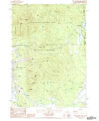
 1987 Silver Lake1987 Print · USGSThe White Mountains and the Swift River valley are captured here in the late 1980s, a period of conservation and quiet village life. Genealogists and local historians can trace family locations near Madison, Chocorua, and the Silver Lake (Madison Sta) railroad area.
 - 1988 Map of Mount Washington, 1989 Print
 1988 Mount Washington1989 Print · USGSThe New Hampshire high country in the late 1980s is defined by its iconic peaks and the legacy of mountain tourism. Trace the routes of the historic Mount Washington Cog Railway and the Maine Central RR through the gaps of Crawford Notch State Park.
End of results
Showing maps 1-9 of 9
Top cities near Conway
- Bridgton historical maps
- Moultonborough historical maps
- Ossipee historical maps
- Fryeburg historical maps
- Bartlett historical maps
- Tamworth historical maps
See more
Top neighborhoods of Conway
- East Conway historical maps
- Redstone historical maps
- Center Conway historical maps
- Intervale historical maps
- South Conway historical maps
- North Conway historical maps
See more
Frequently asked questions
- What are the different types of historical maps available for Conway?
- What is the oldest map of Conway?
- Where can I purchase historical maps of Conway for my home or office?
- Where can I download high-res historical maps of Conway?
- Are there historical topographic maps available for Conway?
- Is there historical aerial imagery available for Conway?
- Where are historical maps of Conway sourced from?