1990s Maps of Dublin, New Hampshire
Explore 6 historic maps of Dublin from the 1990s. These maps offer a rare glimpse into what life looked like during the 1990s — showing old roads, neighborhoods, homes, and landmarks that have changed or disappeared over time.
Whether you're researching your family's past, planning a metal detecting trip, or studying how Dublin's landscape evolved across the 1990s, these high-resolution maps are a powerful tool for exploring the history of this region.
- Focus on a specific era: All maps on this page are from the 1990s, giving you a focused view of this time period.
- See what’s changed: Compare century-old streets, trails, and buildings to today's modern landscape using overlays and satellite layers.
- Research with precision: Use these maps for genealogy, historical research, land use analysis, or educational projects.
- View, download, or print: Maps are fully viewable online in high resolution, and can be downloaded or printed for your own records.
Start exploring Dublin's history through authentic maps from the 1990s. This is your window into the past.
Dublin, NH maps
(6)- 1997 Map of Peterborough North, 1998 Print
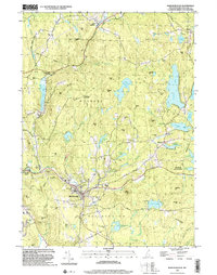
 1997 Peterborough North1998 Print · USGSHillsborough County in the late nineties is a landscape of artist colonies and river-powered hamlets centered on the Contoccook River. Researchers can locate family landmarks such as the St Joseph Minor Seminary Cem or explore the grounds of the historic MacDowell Colony.
 - 1997 Map of Peterborough South, 1998 Print
 1997 Peterborough South1998 Print · USGSHillsborough County's highland forests and river valleys are captured here in the late 1990s, highlighting a landscape defined by conservation and topography. Researchers can trace the Wapack Trail over Barrett Mountain or locate historical settlements like Noone and Squantum.
 - 1998 Map of Marlborough, 2002 Print
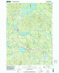
 1998 Marlborough2002 Print · USGSCheshire County at the close of the millennium shows a landscape of small mill villages and dense forests. Genealogists can trace family sites at Meetinghouse Cem or Pine Grove Cem and locate landmarks from the County Fairground to Harrisville.
 - 1998 Map of Dublin, 2002 Print
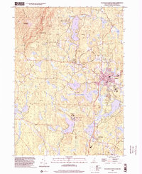
 1998 Dublin2002 Print · USGSCheshire County’s highland terrain and glacial ponds appear in detailed relief during the late 1990s. Researchers can trace the Old Railroad Grade past Harrisville, find the Dublin Spire, or locate old routes like Goldmine Road.
 - 1998 Map of Troy, 2002 Print
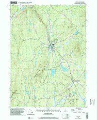 1998 Troy2002 Print · USGSCheshire County at the end of the millennium shows a landscape defined by state forests and historic rail corridors. Researchers can trace the Old Railroad Grade past Fitzwilliam Depot or locate landmarks like the Emerson Sch.
 - 1998 Map of Monadnock Mountain, 2002 Print
 1998 Monadnock Mountain2002 Print · USGSCheshire County at the close of the millennium shows a landscape of outdoor recreation and collegiate growth. Genealogists and hikers can trace paths to Cutler Cem or follow the Monadnock-Sunapee Trail through Monadnock State Park.
End of results
Showing maps 1-6 of 6
Top cities near Dublin
- Keene historical maps
- Winchendon historical maps
- Orange historical maps
- Swanzey historical maps
- Rindge historical maps
- Ashburnham historical maps
See more
Top neighborhoods of Dublin
Frequently asked questions
- What are the different types of historical maps available for Dublin?
- What is the oldest map of Dublin?
- Where can I purchase historical maps of Dublin for my home or office?
- Where can I download high-res historical maps of Dublin?
- Are there historical topographic maps available for Dublin?
- Is there historical aerial imagery available for Dublin?
- Where are historical maps of Dublin sourced from?