1980s Maps of Rindge, New Hampshire
Explore 7 historic maps of Rindge from the 1980s. These maps offer a rare glimpse into what life looked like during the 1980s — showing old roads, neighborhoods, homes, and landmarks that have changed or disappeared over time.
Whether you're researching your family's past, planning a metal detecting trip, or studying how Rindge's landscape evolved across the 1980s, these high-resolution maps are a powerful tool for exploring the history of this region.
- Focus on a specific era: All maps on this page are from the 1980s, giving you a focused view of this time period.
- See what’s changed: Compare century-old streets, trails, and buildings to today's modern landscape using overlays and satellite layers.
- Research with precision: Use these maps for genealogy, historical research, land use analysis, or educational projects.
- View, download, or print: Maps are fully viewable online in high resolution, and can be downloaded or printed for your own records.
Start exploring Rindge's history through authentic maps from the 1980s. This is your window into the past.
Rindge, NH maps
(7)- 1984 Map of Monadnock Mountain
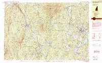 1984 Monadnock Mountain1984 Print · USGSCheshire County in the 1980s remains a landscape of prominent peaks and rail-connected valley towns. Genealogists and hikers can trace the geography of Troy, Fitzwilliam, and Jaffrey Center alongside the trails of Monadnock State Park.2 unique versions available
 - 1984 Map of Lowell
 1984 Lowell1984 Print · USGSThe Merrimack Valley industrial corridor is captured here in the mid-eighties, showing the interconnected growth of Lowell, Nashua, and Lawrence. Genealogists and historians can trace the paths of the Boston and Maine railroad or locate institutional landmarks like Merrimack College and the Fort Devens Military Reservation.
 - 1986 Map of Keene
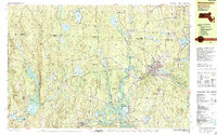
 1986 Keene1986 Print · USGSThe tri-state borderlands of the Connecticut River Valley come alive in this mid-eighties survey of southern Vermont, New Hampshire, and Massachusetts. Genealogists and historians can trace rail-era villages like Ashuelot and Millers Falls alongside landmarks like Marlboro College and Monadnock Mountain.3 unique versions available
 - 1987 Map of Peterborough South
 1987 Peterborough South1987 Print · USGSSouthern New Hampshire’s highlands and forests come alive in the late 1980s, centered on the ridgelines of the TEMPLE MOUNTAIN RANGE. Hikers and local historians can trace the Wapack Trail past peaks and ponds or locate old settlements like Noone and Drury.
 - 1988 Map of Winchendon
 1988 Winchendon1988 Print · USGSNorthern Worcester County and the New Hampshire borderlands are captured here in the late eighties, showing a landscape defined by mill towns and river valleys. Genealogists can locate family sites near Riverside Cemetery, Old Center Cemetery, or the residential clusters in Winchendon Center and South Royalston.2 unique versions available
 - 1988 Map of Ashburnham
 1988 Ashburnham1988 Print · USGSThe Massachusetts-New Hampshire borderlands near Ashburnham appear here in the late eighties as a network of wooded hills and glacial lakes. Genealogists and local historians can trace family locations near St Dennis Cem, North Ashburnham, and Converseville.2 unique versions available
 - 1988 Map of Lowell
 1988 Lowell1988 Print · USGSThe industrial corridor of the Merrimack Valley is captured in the late eighties as it transitioned into a modern technological and residential hub. Genealogists and researchers can trace the urban layouts of Lowell and Nashua alongside landmarks like Massabesic Lake and Miller State Park.2 unique versions available
End of results
Showing maps 1-7 of 7
Top cities near Rindge
- Leominster historical maps
- Fitchburg historical maps
- Keene historical maps
- Gardner historical maps
- Athol historical maps
- Winchendon historical maps
See more
Top neighborhoods of Rindge
- Rand historical maps
- West Rindge historical maps
- Converseville historical maps
- Cutter Hill historical maps
Frequently asked questions
- What are the different types of historical maps available for Rindge?
- What is the oldest map of Rindge?
- Where can I purchase historical maps of Rindge for my home or office?
- Where can I download high-res historical maps of Rindge?
- Are there historical topographic maps available for Rindge?
- Is there historical aerial imagery available for Rindge?
- Where are historical maps of Rindge sourced from?