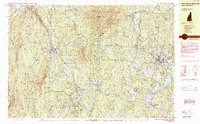
1984 Map of Monadnock Mountain
USGS Topo · Published 1984About this map
Monadnock Mountain towers over this region of southwestern New Hampshire, anchoring a landscape defined by significant conservation tracts and small valley settlements. The industrial and transit patterns of the mid-1980s are clearly visible, with the Boston and Maine RR cutting through the terrain to serve villages like Troy and Fitzwilliam Depot. For genealogists and local historians, the map identifies specific residential clusters such as Bowkerville and Beechwood Corners, along with Pine Grove Cem near Fitzwilliam.
Find a feature on this map
59 named features on this map. Tap any name to fly to it.
Don’t see what you’re looking for? This feature index may not catch every label — zoom into the map to look around manually.
Map Details
Editions of this 1984 Monadnock Mountain Map
2 editions found
Other maps of this area

1887 · Warwick
USGS Topo · 1:62,500

1887 · Winchendon
USGS Topo · 1:62,500

1887 · Fitchburg
USGS Topo · 1:62,500

1889 · Fitchburg
USGS Topo · 1:62,500

1889 · Warwick
USGS Topo · 1:62,500

1890 · Winchendon
USGS Topo · 1:62,500

1893 · Fitchburg
USGS Topo · 1:62,500

1894 · Winchendon
USGS Topo · 1:62,500

1894 · Warwick
USGS Topo · 1:62,500

1898 · Monadnock
USGS Topo · 1:62,500