1980s Maps of Colebrook, New Hampshire
Explore 6 historic maps of Colebrook from the 1980s. These maps offer a rare glimpse into what life looked like during the 1980s — showing old roads, neighborhoods, homes, and landmarks that have changed or disappeared over time.
Whether you're researching your family's past, planning a metal detecting trip, or studying how Colebrook's landscape evolved across the 1980s, these high-resolution maps are a powerful tool for exploring the history of this region.
- Focus on a specific era: All maps on this page are from the 1980s, giving you a focused view of this time period.
- See what’s changed: Compare century-old streets, trails, and buildings to today's modern landscape using overlays and satellite layers.
- Research with precision: Use these maps for genealogy, historical research, land use analysis, or educational projects.
- View, download, or print: Maps are fully viewable online in high resolution, and can be downloaded or printed for your own records.
Start exploring Colebrook's history through authentic maps from the 1980s. This is your window into the past.
Colebrook, NH maps
(6)- 1986 Map of Groveton
 1986 Groveton1986 Print · USGSThe North Country's rugged borderlands come into focus in the mid-1980s, tracing the river-and-rail corridors of the Connecticut River valley. Genealogists and historians can locate family landmarks in North Stratford, Groveton, and Guildhall or trace the Canadian National RR.2 unique versions available
 - 1988 Map of Blue Mountain
 1988 Blue Mountain1988 Print · USGSThe high country of Coos County is revealed in the late eighties, showing a landscape shaped by narrow passes and steep peaks. Researchers can trace the drainage of Simms Stream or locate remote landmarks like Bungy and Cranberry Bog Pond.
 - 1988 Map of Dixville Notch
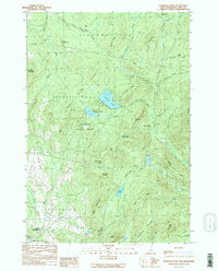
 1988 Dixville Notch1988 Print · USGSThe high mountain passes of Coos County are captured here in the late eighties, just as this wilderness area remained a cornerstone of New Hampshire heritage. Researchers can trace the steep geography of Table Rock, the waters of Lake Gloriette, and the bounds of Dixville Notch State Park.2 unique versions available
 - 1989 Map of Diamond Pond
 1989 Diamond Pond1989 Print · USGSCoos County’s high timberlands and headwaters are captured here in the late eighties, showing a landscape shaped by forestry and northern recreation. Researchers can trace remote camps and early settlements like Felton Camp, Upper Kidderville, and Old Ramsay Camp among the peaks of Tumble Dick Mountain.2 unique versions available
 - 1989 Map of Monadnock Mountain
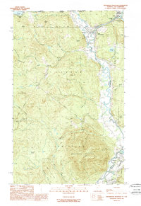 1989 Monadnock Mountain1989 Print · USGSThe northern borderlands of Vermont and New Hampshire come into focus in the late eighties, centered on the Connecticut River valley. Genealogists can trace the rural layout of Beecher Falls, Stewartstown, and Canaan near the Canada line.
 - 1989 Map of Lovering Mountain
 1989 Lovering Mountain1989 Print · USGSThe northern reaches of the Connecticut River valley are captured here in the late eighties as they cross from New Hampshire into Vermont. Researchers can trace local landmarks like Beaver Brook Falls, the Mohawk River, and the settlement of Stewartstown Hollow.2 unique versions available
End of results
Showing maps 1-6 of 6
Top cities near Colebrook
- Stewartstown historical maps
- Pittsburg historical maps
- Stratford historical maps
- Columbia historical maps
- Canaan historical maps
- Dummer historical maps
See more
Top neighborhoods of Colebrook
Frequently asked questions
- What are the different types of historical maps available for Colebrook?
- What is the oldest map of Colebrook?
- Where can I purchase historical maps of Colebrook for my home or office?
- Where can I download high-res historical maps of Colebrook?
- Are there historical topographic maps available for Colebrook?
- Is there historical aerial imagery available for Colebrook?
- Where are historical maps of Colebrook sourced from?