1930s Maps of Lancaster, New Hampshire
Explore 9 historic maps of Lancaster from the 1930s. These maps offer a rare glimpse into what life looked like during the 1930s — showing old roads, neighborhoods, homes, and landmarks that have changed or disappeared over time.
Whether you're researching your family's past, planning a metal detecting trip, or studying how Lancaster's landscape evolved across the 1930s, these high-resolution maps are a powerful tool for exploring the history of this region.
- Focus on a specific era: All maps on this page are from the 1930s, giving you a focused view of this time period.
- See what’s changed: Compare century-old streets, trails, and buildings to today's modern landscape using overlays and satellite layers.
- Research with precision: Use these maps for genealogy, historical research, land use analysis, or educational projects.
- View, download, or print: Maps are fully viewable online in high resolution, and can be downloaded or printed for your own records.
Start exploring Lancaster's history through authentic maps from the 1930s. This is your window into the past.
Lancaster, NH maps
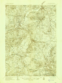
(9)- 1930 Map of Percy, 1953 Print
 1930 Percy1953 Print · USGSCoos County at the start of the thirties centers on the river valleys and rail lines of the North Country. Genealogists can trace the rural schoolhouses of Blake Sch and Hodgdon Hill Sch or locate family landmarks like Beach Hill and Cummings Mtn.5 unique versions available
 - 1931 Map of Guildhall
 1931 Guildhall1931 Print · USGSThe Upper Connecticut River valley was a bustling rail corridor in the early thirties where New Hampshire and Vermont met. Genealogists and rail historians can trace the paths of the Maine Central RR through Groveton or find rural landmarks like East Stratford Sch.
 - 1933 Map of Guildhall
 1933 Guildhall1933 Print · USGSThe Upper Connecticut River Valley thrives during the early thirties as a nexus of New England rail and timber. Trace early families and industry at Maidstone Lake, the Grand Trunk Railway corridor, and the Stone Mtn Firetower.3 unique versions available
 - 1934 Map of Percy
 1934 Percy1934 Print · USGSCoos County, New Hampshire, is shown in the mid-1930s as a landscape of timber camps and isolated valley settlements. Genealogists and historians can locate rural landmarks like the Emerson Sch, the remote Lost Nation community, and the Grand Trunk rail line.3 unique versions available
 - 1935 Map of Whitefield
 1935 Whitefield1935 Print · USGSThe White Mountains region in the mid-1930s shows a landscape of busy rail junctions and early aviation fields. Trace old family plots at Baptist Hill Cem or locate vanished structures near Mill Village and Quebec Junction.4 unique versions available
 - 1935 Map of Mt. Washington
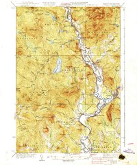
 1935 Mt. Washington1935 Print · USGSCoos County at the height of the Great Depression shows a landscape where mountain rail tourism and rugged hiking trails intersect. Trace the path of the Mount Washington Cog Railway or locate old valley sites like Ravine House and the Gore Sch.4 unique versions available
 - 1937 Map of Guildhall
 1937 Guildhall1937 Print · USGSThe Connecticut River valley comes alive in the 1930s, documenting a landscape of rail-connected river towns and remote mountain bogs. Genealogists and historians can trace the locations of the Chessman Sch, the Maine Central rail lines, and local landmarks like Brunswick Springs.3 unique versions available
 - 1938 Map of Mt. Washington
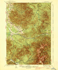 1938 Mt. Washington1938 Print · USGSThe White Mountains in the late 1930s reveal a landscape of mountain resorts and rugged timber camps. Trace the Mount Washington Cog RR, find the Gore Sch, or explore early trail networks like the Crawford Path and Gulfside Trail.4 unique versions available
 - 1938 Map of Whitefield
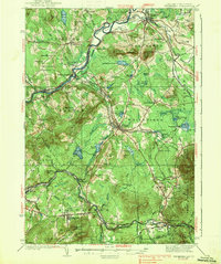 1938 Whitefield1938 Print · USGSCoos County at the end of the Great Depression was a landscape of mountain rail junctions and valley farms. Trace the vanished railroad stops at Quebec Junction, locate family homesteads near Baptist Hill Sch, or find the CCC Camp at Pierce Bridge.3 unique versions available
End of results
Showing maps 1-9 of 9
Top cities near Lancaster
- Berlin historical maps
- Littleton historical maps
- Whitefield historical maps
- Northumberland historical maps
- Milan historical maps
- Lunenburg historical maps
See more
Top neighborhoods of Lancaster
Frequently asked questions
- What are the different types of historical maps available for Lancaster?
- What is the oldest map of Lancaster?
- Where can I purchase historical maps of Lancaster for my home or office?
- Where can I download high-res historical maps of Lancaster?
- Are there historical topographic maps available for Lancaster?
- Is there historical aerial imagery available for Lancaster?
- Where are historical maps of Lancaster sourced from?