1960s Maps of Lincoln, New Hampshire
Explore 8 historic maps of Lincoln from the 1960s. These maps offer a rare glimpse into what life looked like during the 1960s — showing old roads, neighborhoods, homes, and landmarks that have changed or disappeared over time.
Whether you're researching your family's past, planning a metal detecting trip, or studying how Lincoln's landscape evolved across the 1960s, these high-resolution maps are a powerful tool for exploring the history of this region.
- Focus on a specific era: All maps on this page are from the 1960s, giving you a focused view of this time period.
- See what’s changed: Compare century-old streets, trails, and buildings to today's modern landscape using overlays and satellite layers.
- Research with precision: Use these maps for genealogy, historical research, land use analysis, or educational projects.
- View, download, or print: Maps are fully viewable online in high resolution, and can be downloaded or printed for your own records.
Start exploring Lincoln's history through authentic maps from the 1960s. This is your window into the past.
Lincoln, NH maps
(8)- 1961 Map of Lewiston
 1961 Lewiston1961 Print · USGSWestern Maine and the White Mountains appear here during the early sixties, showing the industrial river towns and vast timberlands before the modern interstate era. Genealogists and historians can trace the Grand Trunk RR through Berlin or locate landmarks like Old Speck Mountain and Elephant Mountain.
 - 1962 Map of Lewiston
 1962 Lewiston1962 Print · USGSThe industrial river valleys and high peaks of Maine and New Hampshire define the region in the early sixties. Trace the rail-and-river network from Lewiston to the White Mountains, passing through mill towns like Berlin and Rumford.
 - 1967 Map of Lincoln, 1972 Print
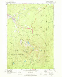
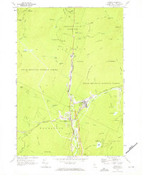 1967 Lincoln1972 Print · USGSGrafton County's mountainous heart is captured here in the late sixties, showing the growth of Lincoln as a mountain gateway. Researchers can trace historic paths like the Appalachian Trail or locate local landmarks including Riverside Cem and the Drive-in Theater.4 unique versions available
 - 1967 Map of Mt. Osceola, 1972 Print
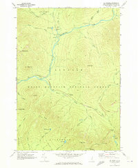 1967 Mt. Osceola1972 Print · USGSGrafton County's interior wilderness is captured here in the late sixties, showing the remote peaks and trail systems of the White Mountain National Forest. Trace the early routes of the Kancamagus Highway and find landmark sites like Thoreau Falls and Greeley Ponds.3 unique versions available
 - 1967 Map of South Twin Mtn, 1972 Print
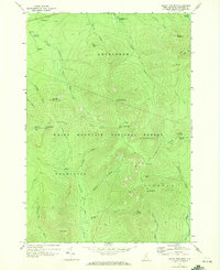 1967 South Twin Mtn1972 Print · USGSThe White Mountains in the late sixties are mapped here in detail, showing the high-altitude trails and peaks of the Twin Range. Trace the Appalachian Trail past the Galehead Hut and the Mt Garfield Lookout Tower.3 unique versions available
 - 1967 Map of Mt Moosilauke, 1973 Print
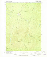 1967 Mt Moosilauke1973 Print · USGSGrafton County in the mid-1960s reveals a high-mountain wilderness where the Appalachian Trail crosses through Kinsman Notch. Researchers can trace the steep geography of Mt Moosilauke and locate landmarks like the Wildwood settlement and Lost River.3 unique versions available
 - 1967 Map of Franconia, 1973 Print
 1967 Franconia1973 Print · USGSGrafton County is shown during a period of high-mountain recreation and road development in the late sixties. Researchers can trace the legendary Old Man of the Mountain, find Franconia College, and locate the historic Elmwood Cem.3 unique versions available
 - 1969 Map of Lewiston
 1969 Lewiston1969 Print · USGSThe northern New England highlands come into focus during the mid-fifties, showing the vital rail and river networks connecting industrial centers to the deep woods. Researchers can trace the path of the Grand Trunk RR or locate landmarks like Mt Washington and Rangeley Lake.
End of results
Showing maps 1-8 of 8
Top cities near Lincoln
- Littleton historical maps
- Campton historical maps
- Bartlett historical maps
- Thornton historical maps
- Whitefield historical maps
- Lisbon historical maps
See more
Top neighborhoods of Lincoln
Frequently asked questions
- What are the different types of historical maps available for Lincoln?
- What is the oldest map of Lincoln?
- Where can I purchase historical maps of Lincoln for my home or office?
- Where can I download high-res historical maps of Lincoln?
- Are there historical topographic maps available for Lincoln?
- Is there historical aerial imagery available for Lincoln?
- Where are historical maps of Lincoln sourced from?