1930s Maps of Monroe, New Hampshire
Explore 6 historic maps of Monroe from the 1930s. These maps offer a rare glimpse into what life looked like during the 1930s — showing old roads, neighborhoods, homes, and landmarks that have changed or disappeared over time.
Whether you're researching your family's past, planning a metal detecting trip, or studying how Monroe's landscape evolved across the 1930s, these high-resolution maps are a powerful tool for exploring the history of this region.
- Focus on a specific era: All maps on this page are from the 1930s, giving you a focused view of this time period.
- See what’s changed: Compare century-old streets, trails, and buildings to today's modern landscape using overlays and satellite layers.
- Research with precision: Use these maps for genealogy, historical research, land use analysis, or educational projects.
- View, download, or print: Maps are fully viewable online in high resolution, and can be downloaded or printed for your own records.
Start exploring Monroe's history through authentic maps from the 1930s. This is your window into the past.
Monroe, NH maps
(6)- 1931 Map of Littleton
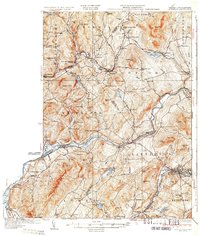
 1931 Littleton1931 Print · USGSUpper Connecticut River Valley life is recorded here in the early thirties, just as aerial photography began to modernize topographic surveying. Genealogists can locate family-named hills and district schools like the Walker Hill Sch and Gilmanton Sch.2 unique versions available
 - 1931 Map of Woodsville
 1931 Woodsville1931 Print · USGSThe Upper Connecticut River Valley in the early 1930s reveals a landscape of riverside rail towns and debated state boundaries. Genealogists and historians can trace the foundations of local life through labels like the North Monroe Ch, Blackmount Sta, and the County Poor Farm.
 - 1932 Map of Littleton
 1932 Littleton1932 Print · USGSThe Upper Connecticut River valley and the hills of Vermont's Northeast Kingdom appear here in the early thirties. Trace family connections through numerous rural schoolhouses like Sugar Hill Sch or locate the old Kirby Mtn Quarries and the original path of the Maine Central Railroad.3 unique versions available
 - 1935 Map of Woodsville
 1935 Woodsville1935 Print · USGSThe Connecticut River valley in the mid-1930s is captured here in detail along the Vermont-New Hampshire border. Researchers can trace the legacy of local institutions and transport at the County Poor Farm, the Blackmount Sta rail stop, and The Oxbow.5 unique versions available
 - 1935 Map of Littleton
 1935 Littleton1935 Print · USGSThe Upper Connecticut River Valley comes alive in the mid-1930s, showing the borderlands of Vermont and New Hampshire during a period of hydroelectric and rail expansion. Researchers can trace the legacy of local education and industry through sites like the Kirby Mtn Quarries, the Frank D. Comerford Hydro-Electric Plant, and the Slate Ledge Sch.4 unique versions available
 - 1938 Map of St. Johnsbury
 1938 St. Johnsbury1938 Print · USGSNorthern Vermont in the late thirties reveals a landscape of rail-connected valley towns and upland farming districts. Locate old schoolhouses like Stark Sch, trace the St Johnsbury and Lake Champlain RR, and find family landmarks near Harvey Lake.
End of results
Showing maps 1-6 of 6
Top cities near Monroe
- Saint Johnsbury historical maps
- Littleton historical maps
- Haverhill historical maps
- Danville historical maps
- Newbury historical maps
- Newbury Village historical maps
See more
Frequently asked questions
- What are the different types of historical maps available for Monroe?
- What is the oldest map of Monroe?
- Where can I purchase historical maps of Monroe for my home or office?
- Where can I download high-res historical maps of Monroe?
- Are there historical topographic maps available for Monroe?
- Is there historical aerial imagery available for Monroe?
- Where are historical maps of Monroe sourced from?