1930s Maps of Piermont, New Hampshire
Explore 6 historic maps of Piermont from the 1930s. These maps offer a rare glimpse into what life looked like during the 1930s — showing old roads, neighborhoods, homes, and landmarks that have changed or disappeared over time.
Whether you're researching your family's past, planning a metal detecting trip, or studying how Piermont's landscape evolved across the 1930s, these high-resolution maps are a powerful tool for exploring the history of this region.
- Focus on a specific era: All maps on this page are from the 1930s, giving you a focused view of this time period.
- See what’s changed: Compare century-old streets, trails, and buildings to today's modern landscape using overlays and satellite layers.
- Research with precision: Use these maps for genealogy, historical research, land use analysis, or educational projects.
- View, download, or print: Maps are fully viewable online in high resolution, and can be downloaded or printed for your own records.
Start exploring Piermont's history through authentic maps from the 1930s. This is your window into the past.
Piermont, NH maps
(6)- 1931 Map of Mt. Cube
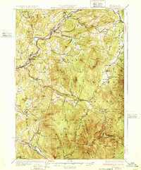
 1931 Mt. Cube1931 Print · USGSThe Connecticut River valley and the foothills of the White Mountains are shown here as they appeared in the early 1930s. Genealogists and hikers can trace the Appalachian Trail, locate rural schools like Blood Brook Sch, or find family sites near Quinttown.3 unique versions available
 - 1931 Map of Woodsville
 1931 Woodsville1931 Print · USGSThe Upper Connecticut River Valley in the early 1930s reveals a landscape of riverside rail towns and debated state boundaries. Genealogists and historians can trace the foundations of local life through labels like the North Monroe Ch, Blackmount Sta, and the County Poor Farm.
 - 1932 Map of Rumney
 1932 Rumney1932 Print · USGSThe Baker River valley in the early 1930s shows a landscape of mountain rail stops and rural schoolhouses. Genealogists can trace family landmarks and forgotten stops like Swainboro Sta, Weeks Crossing, and the Buffalo Sch.5 unique versions available
 - 1932 Map of Moosilauke
 1932 Moosilauke1932 Print · USGSGrafton County is captured in the early thirties as a hub of mountain recreation and rail transport within the White Mountain National Forest. Genealogists and hikers can trace early routes of the Appalachian Trail and locate family landmarks like Moulton Hill Cemetery or Pettyboro Sch.5 unique versions available
 - 1933 Map of Mt. Cube
 1933 Mt. Cube1933 Print · USGSThe Upper Connecticut River valley is shown in the early thirties, where rail and river networks linked New Hampshire and Vermont. Genealogists and local historians can trace schoolhouses like Stetson Sch, the remote Quinttown settlement, and the historic Mt Cube House.6 unique versions available
 - 1935 Map of Woodsville
 1935 Woodsville1935 Print · USGSThe Connecticut River valley in the mid-1930s is captured here in detail along the Vermont-New Hampshire border. Researchers can trace the legacy of local institutions and transport at the County Poor Farm, the Blackmount Sta rail stop, and The Oxbow.5 unique versions available
End of results
Showing maps 1-6 of 6
Top cities near Piermont
- Hanover historical maps
- Haverhill historical maps
- Norwich historical maps
- Newbury historical maps
- Newbury Village historical maps
- Lyme historical maps
See more
Frequently asked questions
- What are the different types of historical maps available for Piermont?
- What is the oldest map of Piermont?
- Where can I purchase historical maps of Piermont for my home or office?
- Where can I download high-res historical maps of Piermont?
- Are there historical topographic maps available for Piermont?
- Is there historical aerial imagery available for Piermont?
- Where are historical maps of Piermont sourced from?