1970s Maps of Rumney, New Hampshire
Explore 3 historic maps of Rumney from the 1970s. These maps offer a rare glimpse into what life looked like during the 1970s — showing old roads, neighborhoods, homes, and landmarks that have changed or disappeared over time.
Whether you're researching your family's past, planning a metal detecting trip, or studying how Rumney's landscape evolved across the 1970s, these high-resolution maps are a powerful tool for exploring the history of this region.
- Focus on a specific era: All maps on this page are from the 1970s, giving you a focused view of this time period.
- See what’s changed: Compare century-old streets, trails, and buildings to today's modern landscape using overlays and satellite layers.
- Research with precision: Use these maps for genealogy, historical research, land use analysis, or educational projects.
- View, download, or print: Maps are fully viewable online in high resolution, and can be downloaded or printed for your own records.
Start exploring Rumney's history through authentic maps from the 1970s. This is your window into the past.
Rumney, NH maps
(3)- 1973 Map of Rumney, 1975 Print
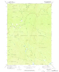
 1973 Rumney1975 Print · USGSGrafton County's river valleys and mountain slopes are captured here in the early 1970s, showcasing the high-elevation terrain of the White Mountain National Forest. Researchers can trace rural life from Rumney Depot to North Groton, locating the Russell Sch, several Cem sites, and the Railroad Grade along the Baker River.
 - 1973 Map of Mount Kineo, 1975 Print
 1973 Mount Kineo1975 Print · USGSGrafton County's high ridges and recreational camps are captured here in the early 1970s, as the forest was becoming a primary destination for hikers and skiers. Trace the Appalachian Tr, find the McKenney Cabin, or locate the shores of Stinson Lake and Foxglove Pond.2 unique versions available
 - 1974 Map of Wentworth, 1975 Print
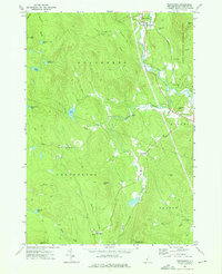 1974 Wentworth1975 Print · USGSGrafton County in the mid-1970s reveals a landscape of mountain hamlets and river valleys defined by the White Mountain National Forest. Trace the Old Railroad Grade near Wentworth or locate Pleasant View Cem and the settlement at Cheever.3 unique versions available
End of results
Showing maps 1-3 of 3
Top cities near Rumney
- Plymouth historical maps
- Enfield historical maps
- Haverhill historical maps
- Campton historical maps
- Bristol historical maps
- Thornton historical maps
See more
Top neighborhoods of Rumney
- Quincy historical maps
- Rumney Depot historical maps
- Stinson Lake historical maps
- West Rumney historical maps
Frequently asked questions
- What are the different types of historical maps available for Rumney?
- What is the oldest map of Rumney?
- Where can I purchase historical maps of Rumney for my home or office?
- Where can I download high-res historical maps of Rumney?
- Are there historical topographic maps available for Rumney?
- Is there historical aerial imagery available for Rumney?
- Where are historical maps of Rumney sourced from?