1950s Maps of Nashua, New Hampshire
Explore 6 historic maps of Nashua from the 1950s. These maps offer a rare glimpse into what life looked like during the 1950s — showing old roads, neighborhoods, homes, and landmarks that have changed or disappeared over time.
Whether you're researching your family's past, planning a metal detecting trip, or studying how Nashua's landscape evolved across the 1950s, these high-resolution maps are a powerful tool for exploring the history of this region.
- Focus on a specific era: All maps on this page are from the 1950s, giving you a focused view of this time period.
- See what’s changed: Compare century-old streets, trails, and buildings to today's modern landscape using overlays and satellite layers.
- Research with precision: Use these maps for genealogy, historical research, land use analysis, or educational projects.
- View, download, or print: Maps are fully viewable online in high resolution, and can be downloaded or printed for your own records.
Start exploring Nashua's history through authentic maps from the 1950s. This is your window into the past.
Nashua, NH maps
(6)- 1950 Map of Pepperell, 1952 Print
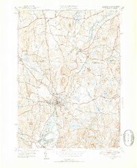 1950 Pepperell1952 Print · USGSThe borderlands of Massachusetts and New Hampshire are captured here at mid-century, centered on the river junctions and rail lines of the Nashua valley. Genealogists and local historians can trace the Boston and Maine tracks to the Hollis Depot or locate family plots at St Joseph Cem and Woodlawn Cem.4 unique versions available
 - 1950 Map of Tyngsboro, 1952 Print
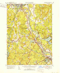 1950 Tyngsboro1952 Print · USGSThe Merrimack River valley at the mid-century mark reveals a landscape of growing towns and academic centers along the New Hampshire border. Researchers can trace old family sites like Frederick Corner, locate the Flat Rock Quarry, or find the Old Dunstable Cem.3 unique versions available
 - 1953 Map of Manchester, 1958 Print
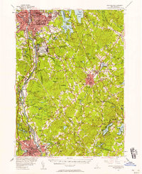 1953 Manchester1958 Print · USGSSouthern New Hampshire thrives in the early fifties as industrial cities and military installations like Grenier Air Force Base anchor the Merrimack Valley. Trace ancestral roots at St Josephs Cem or locate old river crossings like Thorntons Ferry.4 unique versions available
 - 1953 Map of Milford, 1958 Print
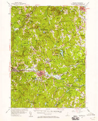 1953 Milford1958 Print · USGSHillsborough County in the early fifties shows a landscape of growing towns and established institutions. Trace family roots and local history near Milford or explore the mid-century layout of St Anselms College and the Baboosic Lake shoreline.3 unique versions available
 - 1956 Map of Boston, 1967 Print
 1956 Boston1967 Print · USGSThe Massachusetts coastline and industrial interior are seen here during the mid-century peak of suburban and highway expansion. Researchers can trace historic harbor defenses like Fort Revere, local landmarks such as Faneuil Hall, and the vast Parker River National Wildlife Refuge.6 unique versions available
 - 1958 Map of Boston
 1958 Boston1958 Print · USGSEastern Massachusetts and southern New Hampshire are shown at the height of the industrial era, before the full expansion of the interstate system. Trace coastal defenses at Fort Warren, historic rail lines like the Boston and Maine, and the development of the Mass. 128 corridor.2 unique versions available
End of results
Showing maps 1-6 of 6
Top cities near Nashua
- Manchester historical maps
- Lowell historical maps
- Leominster historical maps
- Billerica historical maps
- Derry historical maps
- Chelmsford historical maps
See more
Top neighborhoods of Nashua
- Ward 1 historical maps
- Ward 3 historical maps
- Ward 5 historical maps
- Ward 7 historical maps
- Ward 8 historical maps
- Ward 2 historical maps
See more
Frequently asked questions
- What are the different types of historical maps available for Nashua?
- What is the oldest map of Nashua?
- Where can I purchase historical maps of Nashua for my home or office?
- Where can I download high-res historical maps of Nashua?
- Are there historical topographic maps available for Nashua?
- Is there historical aerial imagery available for Nashua?
- Where are historical maps of Nashua sourced from?