1990s Maps of New Boston, New Hampshire
Explore 5 historic maps of New Boston from the 1990s. These maps offer a rare glimpse into what life looked like during the 1990s — showing old roads, neighborhoods, homes, and landmarks that have changed or disappeared over time.
Whether you're researching your family's past, planning a metal detecting trip, or studying how New Boston's landscape evolved across the 1990s, these high-resolution maps are a powerful tool for exploring the history of this region.
- Focus on a specific era: All maps on this page are from the 1990s, giving you a focused view of this time period.
- See what’s changed: Compare century-old streets, trails, and buildings to today's modern landscape using overlays and satellite layers.
- Research with precision: Use these maps for genealogy, historical research, land use analysis, or educational projects.
- View, download, or print: Maps are fully viewable online in high resolution, and can be downloaded or printed for your own records.
Start exploring New Boston's history through authentic maps from the 1990s. This is your window into the past.
New Boston, NH maps
(5)- 1995 Map of Goffstown, 1999 Print
 1995 Goffstown1999 Print · USGSMerrimack County in the mid-1990s shows a transition from river-valley settlements to upland pond and hill country. Researchers can trace local history through sites like Holy Trinity Cemetery, the old crossroads at Dunbarton Center, and industrial landmarks near Goffstown.
 - 1995 Map of Weare, 1999 Print
 1995 Weare1999 Print · USGSHillsborough County villages and the Piscataquog valley are captured here in the mid-nineties. Genealogists and local historians can trace the Old Railroad Grade past Tavern Village or locate family plots at Quaker Cem and Pine Grove Cem.
 - 1995 Map of Greenfield, 1999 Print
 1995 Greenfield1999 Print · USGSHillsborough County's highland landscape is captured in the mid-nineties, showing the rugged connection between hilltop summits and valley settlements. Genealogists and local historians can trace family-named landmarks from Gould Hill to Francestown and locate historic water bodies like Haunted Lake.
 - 1995 Map of New Boston, 1999 Print
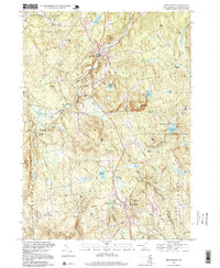 1995 New Boston1999 Print · USGSHillsborough County in the mid-nineties shows a mix of rural tradition and modern technology. Researchers can trace family-named summits like Cochran Hill or visit the New Hampshire Satellite Tracking Station and Purgatory Falls.
 - 1998 Map of Deering, 2001 Print
 1998 Deering2001 Print · USGSThe hills of southern New Hampshire are captured here as they appeared in the late twentieth century. Genealogists and local historians can trace small settlements like Chase Village and Slab City, or locate family landmarks including Bartlett Hill and Goodale Hill.
End of results
Showing maps 1-5 of 5
Top cities near New Boston
- Manchester historical maps
- Nashua historical maps
- Concord historical maps
- Merrimack historical maps
- Hudson historical maps
- Bedford historical maps
See more
Top neighborhoods of New Boston
Frequently asked questions
- What are the different types of historical maps available for New Boston?
- What is the oldest map of New Boston?
- Where can I purchase historical maps of New Boston for my home or office?
- Where can I download high-res historical maps of New Boston?
- Are there historical topographic maps available for New Boston?
- Is there historical aerial imagery available for New Boston?
- Where are historical maps of New Boston sourced from?