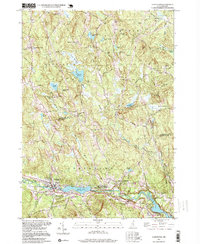
1995 Map of Goffstown
USGS Topo · Published 1999About this map
Goffstown and Grasmere anchor the southern reaches of this landscape, situated along the winding course of the Piscataquog River. The river forms a central axis for the community, expanding into Glen Lake and providing a focal point for the Glen Lake/Greggs Falls/Piscataquog River State Wildlife Management Area. To the north, the terrain becomes increasingly complex, characterized by numerous water bodies like Kimball Pond, Long Pond, and Purgatory Pond, as well as the prominent heights of Quimby Mtn and Wood Hill.
Find a feature on this map
58 named features on this map. Tap any name to fly to it.
Don’t see what you’re looking for? This feature index may not catch every label — zoom into the map to look around manually.
Map Details
Editions of this 1995 Goffstown Map
This is the sole edition of this map. No revisions or reprints were ever made.
Other maps of this area

1905 · Manchester
USGS Topo · 1:62,500

1906 · Milford
USGS Topo · 1:62,500

1921 · Suncook
USGS Topo · 1:62,500

1927 · Concord
USGS Topo · 1:62,500

1941 · Manchester
USGS Topo · 1:62,500

1943 · Lowell
USGS Topo · 1:125,000

1943 · Fitchburg
USGS Topo · 1:125,000

1944 · Suncook
USGS Topo · 1:62,500

1948 · Boston
USGS Topo · 1:250,000

1949 · Portland
USGS Topo · 1:250,000