1980s Maps of Northwood, New Hampshire
Explore 5 historic maps of Northwood from the 1980s. These maps offer a rare glimpse into what life looked like during the 1980s — showing old roads, neighborhoods, homes, and landmarks that have changed or disappeared over time.
Whether you're researching your family's past, planning a metal detecting trip, or studying how Northwood's landscape evolved across the 1980s, these high-resolution maps are a powerful tool for exploring the history of this region.
- Focus on a specific era: All maps on this page are from the 1980s, giving you a focused view of this time period.
- See what’s changed: Compare century-old streets, trails, and buildings to today's modern landscape using overlays and satellite layers.
- Research with precision: Use these maps for genealogy, historical research, land use analysis, or educational projects.
- View, download, or print: Maps are fully viewable online in high resolution, and can be downloaded or printed for your own records.
Start exploring Northwood's history through authentic maps from the 1980s. This is your window into the past.
Northwood, NH maps
(5)- 1981 Map of Northwood
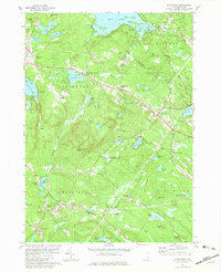 1981 Northwood1981 Print · USGSSoutheastern New Hampshire’s lake country is captured here in the early eighties, showcasing the historic village clusters of Northwood and Deerfield. Genealogists and historians can trace family landmarks like Bartlett Cem, find the old White Sch, or locate the radio tower on Saddleback Mountain.3 unique versions available
 - 1986 Map of Concord
 1986 Concord1986 Print · USGSCentral New Hampshire in the mid-eighties shows a landscape of river-valley cities and rural villages connected by the growing interstate system. Genealogists and historians can trace old community centers like Gilmanton Ironworks or follow the Boston and Maine Railroad through Concord and Tilton.
 - 1987 Map of Pittsfield
 1987 Pittsfield1987 Print · USGSMerrimack County comes into focus in the late 1980s as the Suncook River flows through the industrial hub of Pittsfield. Genealogists and local historians can trace the Old Railroad Grade or locate family landmarks like Websters Mill and Sanborn Hill.
 - 1987 Map of Parker Mountain
 1987 Parker Mountain1987 Print · USGSThe rural hills of Strafford and Barnstead are captured here in the late twentieth century, showing a landscape defined by traditional family-named crossroads. Researchers can locate historic burial sites at several mapped cemeteries or trace the geography of old homesteads near Lockes Corner, Shackford Corners, and the shores of Bow Lake.2 unique versions available
 - 1988 Map of Concord
 1988 Concord1988 Print · USGSCentral New Hampshire in the late eighties centers on the industrial and political hub of Concord. Researchers can trace the Boston and Maine RR along the Merrimack River or locate recreation landmarks like Bear Brook State Park and Massabesic Lake.
End of results
Showing maps 1-5 of 5
Top cities near Northwood
- Manchester historical maps
- Rochester historical maps
- Hooksett historical maps
- Durham historical maps
- Exeter historical maps
- Barrington historical maps
See more
Top neighborhoods of Northwood
- Northwood Center historical maps
- Melrose Beach historical maps
- Northwood Narrows historical maps
- Northwood Ridge historical maps
Frequently asked questions
- What are the different types of historical maps available for Northwood?
- What is the oldest map of Northwood?
- Where can I purchase historical maps of Northwood for my home or office?
- Where can I download high-res historical maps of Northwood?
- Are there historical topographic maps available for Northwood?
- Is there historical aerial imagery available for Northwood?
- Where are historical maps of Northwood sourced from?