1900s (20th Century) Maps of Alpine, New Jersey
Explore 26 historic maps of Alpine from the 1900s (20th Century). These maps offer a rare glimpse into what life looked like during the 1900s — showing old roads, neighborhoods, homes, and landmarks that have changed or disappeared over time.
Whether you're researching your family's past, planning a metal detecting trip, or studying how Alpine's landscape evolved across the 1900s, these high-resolution maps are a powerful tool for exploring the history of this region.
- Focus on a specific era: All maps on this page are from the 1900s, giving you a focused view of this time period.
- See what’s changed: Compare century-old streets, trails, and buildings to today's modern landscape using overlays and satellite layers.
- Research with precision: Use these maps for genealogy, historical research, land use analysis, or educational projects.
- View, download, or print: Maps are fully viewable online in high resolution, and can be downloaded or printed for your own records.
Start exploring Alpine's history through authentic maps from the 1900s. This is your window into the past.
Alpine, NJ maps
(26)- 1900 Map of Harlem
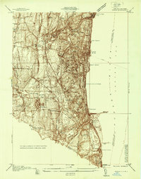
 1900 Harlem1900 Print · USGSUpper Manhattan and the surrounding boroughs are shown at a pivotal moment of growth before the mid-century building boom. Genealogists can trace family footprints through the streets of Yonkers Park or locate ancestors in the sprawling Woodlawn Cemetery.16 unique versions available
 - 1902 Map of Tarrytown
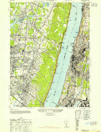
 1902 Tarrytown1902 Print · USGSThe Hudson River valley at the turn of the century shows a landscape of busy river landings and nascent suburbs. Genealogists and historians can trace old homesteads and landmarks like Waldberg Landing, the State Prison at Ossining, and the Croton Aqueduct.11 unique versions available
 - 1937 Map of Nyack
 1937 Nyack1937 Print · USGSRockland County’s riverfront and wooded interior are shown here in the late 1930s as the rail-and-river economy remained in full swing. Genealogists and historians can trace family locations near the Rockland State Hospital, Piermont, and the St Catharines Cem.
 - 1937 Map of Tarrytown
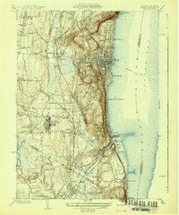
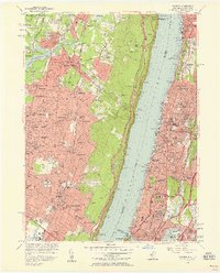
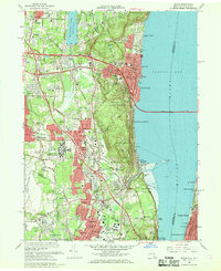
 1937 Tarrytown1937 Print · USGSThe Hudson River valley during the 1930s serves as a busy corridor of rail, water, and infrastructure. Genealogists and local historians can trace the old landings at Waldberg Landing, the grounds of the State Prison in Ossining, and the rail lines through Nyack.
 - 1940 Map of Nyack, 1952 Print
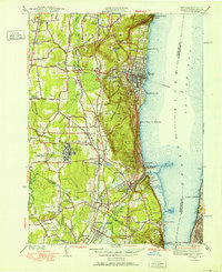 1940 Nyack1952 Print · USGSThe Hudson River shoreline and Rockland County interior are captured here just before mid-century suburban expansion. Researchers can trace the extensive grounds of the Rockland State Hospital, the paths of the West Shore RR, and historic sites like Sneden Landing.
 - 1942 Map of Nyack
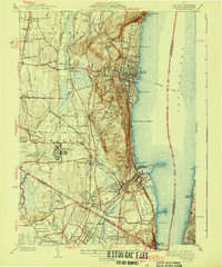
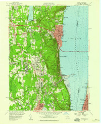
 1942 Nyack1942 Print · USGSThe Hudson River riverfront and the high ridges of the Palisades define this area in the early years of the war. Researchers can trace the legacy of rail and river travel through the Tarrytown Ferry and the Erie RR, or locate family sites near Sneden Landing and Rockland State Hospital.
 - 1943 Map of Nyack
 1943 Nyack1943 Print · USGSSoutheastern Rockland County and the Bergen County border are shown in the early 1940s as riverfront villages and rail-dependent towns. Trace the sprawling grounds of the Rockland State Hospital or locate ancestors in Oak Hill Cemetery and Rockland Cemetery.2 unique versions available
 - 1947 Map of Yonkers
 1947 Yonkers1947 Print · USGSThe Hudson River waterfronts of New York and New Jersey are captured here in the late forties, showing a landscape of suburban growth and industrial strength. Trace the old rail lines of the West Shore RR and find historic sites like the Spreckel Estate and N Y Colored Orphan Asylum.2 unique versions available
 - 1947 Map of Hartford, 1955 Print
 1947 Hartford1955 Print · USGSSouthern New England and the Hudson Valley are shown in detail during the post-war expansion era. Genealogists and researchers can trace local landmarks from the State Capitol and Yale University to the Stratford Lighthouse and Woodlawn Cem.2 unique versions available
 - 1948 Map of Hartford
 1948 Hartford1948 Print · USGSSouthern New England is captured here in the late 1940s, showcasing a landscape of thriving industrial cities and developing parkways. Genealogists and historians can trace the rail networks of the New York New Haven and Hartford RR or locate coastal defense sites like Fort Terry and Camp Shanks.2 unique versions available
 - 1949 Map of New York, 1951 Print
 1949 New York1951 Print · USGSLong Island and its surrounding waters are documented here in the late 1940s, just as the postwar suburban boom began to transform the region. Genealogists and historians can trace the early layouts of Idlewild Airport, Mitchell Field, and the established routes of the Long Island RR.
 - 1954 Map of New York
 1954 New York1954 Print · USGSLong Island and the New York metropolitan area are shown during the height of post-war suburbanization. Genealogists and historians can trace the growth of Levittown, the infrastructure of the Long Island Rail Road, and landmarks like Mitchel Afb.2 unique versions available
 - 1956 Map of Yonkers, 1958 Print
 1956 Yonkers1958 Print · USGSThe Hudson River corridor in the mid-fifties shows the dense expansion of Yonkers and Englewood just as new parkways began to reshape the suburbs. Genealogists can trace family footprints across Woodlawn Cemetery, locate local parish schools like St Cecilia Sch, or find vanished river docks like Powder Dock.2 unique versions available
 - 1957 Map of Nyack, 1959 Print
 1957 Nyack1959 Print · USGSRockland County is seen during a period of rapid post-war growth as the new Thruway begins to reshape the Hudson riverfront. Trace the grounds of Rockland State Hospital, locate the historic Old Stone Ch, or follow the rail lines of the Erie RR through Orangeburg.2 unique versions available
 - 1957 Map of New York, 1975 Print
 1957 New York1975 Print · USGSLong Island and the New York metropolitan area are shown in this mid-century survey during a period of massive suburban growth and industrial expansion. Researchers can trace the Long Island RR network and locate landmarks like Fort Tilden or the Brookhaven National Laboratory.
 - 1958 Map of New York
 1958 New York1958 Print · USGSLong Island at the height of its postwar expansion reveals a landscape of rapidly growing suburbs and critical military installations. Genealogists and historians can trace the early footprints of Levittown, the terminals of Idlewild Airport, and the grounds of Brookhaven National Laboratory.3 unique versions available
 - 1960 Map of New York, 1979 Print
 1960 New York1979 Print · USGSLong Island and the five boroughs are shown at a transformative moment mid-century as suburban expansion reshaped the landscape. Researchers can trace family roots through evolving neighborhoods from Rockville Centre to Sayville, or locate historic maritime landmarks like Eatons Neck and Montauk Point.2 unique versions available
 - 1961 Map of Hartford
 1961 Hartford1961 Print · USGSSouthern New England and the Hudson Valley are shown here in the mid-fifties, capturing a landscape of booming coastal cities and interior hill towns. Researchers can trace the legacy of the New York New Haven and Hartford rail corridor and find strategic sites like Camp Shanks and Fort Michie.
 - 1962 Map of Hartford, 1971 Print
 1962 Hartford1971 Print · USGSSouthern New England and the Hudson Valley are shown in the early sixties, as suburban growth reached into the foothills. Trace the path of the New York New Haven & Hartford RR and find landmarks like Camp Nathan Hale and Gillette Castle State Park.3 unique versions available
 - 1965 Map of Hartford
 1965 Hartford1965 Print · USGSSouthern New England and the Hudson Valley are shown here during the mid-sixties expansion of the Interstate era. Trace the path of the New York New Haven & Hartford RR or locate historic landmarks like West Point Military Reservation and the Merritt Parkway.2 unique versions available
 - 1966 Map of Yonkers, 1968 Print
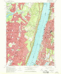 1966 Yonkers1968 Print · USGSThe Hudson River divides Bergen County and the Bronx in the mid-1960s, showing a region defined by its topography and rapid suburbanization. Local historians can trace the development of Yonkers and Englewood alongside landmarks like Manhattan College and the Camp Merritt Mon.3 unique versions available
 - 1967 Map of Nyack, 1969 Print
 1967 Nyack1969 Print · USGSThe Hudson River's western shore in the late sixties reveals a landscape of established riverfront villages and growing suburban institutions. Genealogists and historians can trace Oak Hill Cemetery, the Rockland State Hospital, and the historic enclave at Sneden Landing.3 unique versions available
 - 1969 Map of New York
 1969 New York1969 Print · USGSLong Island and the New York harbor area are shown here during a peak era of suburban expansion and Cold War defense. Trace the growth of Levittown, the infrastructure of Idlewild NY International Airport, and the reach of the Long Island RR.
 - 1984 Map of Long Island West, 1986 Print
 1984 Long Island West1986 Print · USGSWestern Long Island in the mid-eighties shows a mature suburban landscape defined by its famous expressways and historic rail lines. Researchers can trace the development of planned communities like Levittown or locate landmarks such as Fort Totten Mil Res and Stony Brook.2 unique versions available
 - 1986 Map of Bridgeport
 1986 Bridgeport1986 Print · USGSSpanning the New York and Connecticut border in the mid-eighties, this survey shows the dense rail and parkway network connecting the Hudson to the Sound. Researchers can trace the massive New Croton Reservoir system or locate landmarks like the West Point U.S. Military Academy.3 unique versions available
Showing maps 1-25 of 26
Top cities near Alpine
- New York historical maps
- Hempstead historical maps
- Newark historical maps
- Jersey City historical maps
- North Hempstead historical maps
- Yonkers historical maps
See more
Frequently asked questions
- What are the different types of historical maps available for Alpine?
- What is the oldest map of Alpine?
- Where can I purchase historical maps of Alpine for my home or office?
- Where can I download high-res historical maps of Alpine?
- Are there historical topographic maps available for Alpine?
- Is there historical aerial imagery available for Alpine?
- Where are historical maps of Alpine sourced from?