1990s Maps of Mount Laurel Township, New Jersey
Explore 2 historic maps of Mount Laurel Township from the 1990s. These maps offer a rare glimpse into what life looked like during the 1990s — showing old roads, neighborhoods, homes, and landmarks that have changed or disappeared over time.
Whether you're researching your family's past, planning a metal detecting trip, or studying how Mount Laurel Township's landscape evolved across the 1990s, these high-resolution maps are a powerful tool for exploring the history of this region.
- Focus on a specific era: All maps on this page are from the 1990s, giving you a focused view of this time period.
- See what’s changed: Compare century-old streets, trails, and buildings to today's modern landscape using overlays and satellite layers.
- Research with precision: Use these maps for genealogy, historical research, land use analysis, or educational projects.
- View, download, or print: Maps are fully viewable online in high resolution, and can be downloaded or printed for your own records.
Start exploring Mount Laurel Township's history through authentic maps from the 1990s. This is your window into the past.
Mount Laurel Township, NJ maps
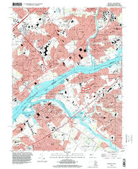
(2)- 1995 Map of Moorestown, 1998 Print
 1995 Moorestown1998 Print · USGSSouth Jersey's suburban landscape reached a peak of development in the late nineties, centered on the busy intersection of the New Jersey Turnpike. Researchers can trace the layout of residential tracts like Heritage Village or locate historic sites like Colestown Cemetery and the Cistercian Monastery.
 - 1995 Map of Beverly, 2000 Print
 1995 Beverly2000 Print · USGSCrossing the Delaware during the mid-1990s reveals a suburban landscape still deeply shaped by its riverfront heritage and industrial rail corridors. Genealogists can trace family sites from Beverly National Cemetery to the Philadelphia State Hospital or the historic Byberry Chapel.
End of results
Showing maps 1-2 of 2
Top cities near Mount Laurel Township
- Philadelphia historical maps
- Hamilton Township historical maps
- Camden historical maps
- Cherry Hill Township historical maps
- Bensalem Township historical maps
- Abington Township historical maps
See more
Top neighborhoods of Mount Laurel Township
- Fellowship historical maps
- Birchfield historical maps
- Masonville historical maps
- Centerton historical maps
- Coxs Corner historical maps
- Hartford historical maps
See more
Frequently asked questions
- What are the different types of historical maps available for Mount Laurel Township?
- What is the oldest map of Mount Laurel Township?
- Where can I purchase historical maps of Mount Laurel Township for my home or office?
- Where can I download high-res historical maps of Mount Laurel Township?
- Are there historical topographic maps available for Mount Laurel Township?
- Is there historical aerial imagery available for Mount Laurel Township?
- Where are historical maps of Mount Laurel Township sourced from?