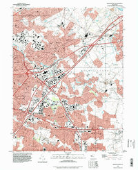
1995 Map of Moorestown
USGS Topo · Published 1998About this map
Moorestown and its surrounding suburbs define this mid-1990s landscape, illustrating the suburban density of Burlington County. The terrain is bifurcated by the New Jersey Turnpike, which intersects major local arteries like Kings Highway and Fellowship Road. This era shows a fully developed commercial and residential network, centered around the Moorestown Mall Shopping Center and extending into established communities like Maple Shade and Lenola.
Find a feature on this map
126 named features on this map. Tap any name to fly to it.
Don’t see what you’re looking for? This feature index may not catch every label — zoom into the map to look around manually.
Map Details
Editions of this 1995 Moorestown Map
This is the sole edition of this map. No revisions or reprints were ever made.
Other maps of this area

1888 · Mount Holly
USGS Topo · 1:62,500

1890 · Burlington
USGS Topo · 1:62,500

1891 · Philadelphia
USGS Topo · 1:62,500

1893 · Germantown
USGS Topo · 1:62,500

1893 · Burlington
USGS Topo · 1:62,500

1894 · Mount Holly
USGS Topo · 1:62,500

1894 · Philadelphia
USGS Topo · 1:62,500

1894 · Germantown
USGS Topo · 1:62,500

1896 · Germantown
USGS Topo · 1:62,500

1896 · Philadelphia
USGS Topo · 1:62,500
Featured Places
- Cherry Hill Township, NJ
- Mount Laurel Township, NJ
- Willingboro Township, NJ
- Moorestown Township, NJ
- Maple Shade Township, NJ