1900s (20th Century) Maps of Ewansville, Southampton Township
Explore 14 historic maps of Ewansville from the 1900s (20th Century). These maps offer a rare glimpse into what life looked like during the 1900s — showing old roads, neighborhoods, homes, and landmarks that have changed or disappeared over time.
Whether you're researching your family's past, planning a metal detecting trip, or studying how Ewansville's landscape evolved across the 1900s, these high-resolution maps are a powerful tool for exploring the history of this region.
- Focus on a specific era: All maps on this page are from the 1900s, giving you a focused view of this time period.
- See what’s changed: Compare century-old streets, trails, and buildings to today's modern landscape using overlays and satellite layers.
- Research with precision: Use these maps for genealogy, historical research, land use analysis, or educational projects.
- View, download, or print: Maps are fully viewable online in high resolution, and can be downloaded or printed for your own records.
Start exploring Ewansville's history through authentic maps from the 1900s. This is your window into the past.
Ewansville, Southampton Township maps
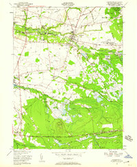
(14)- 1900 Map of Rancocas
 1900 Rancocas1900 Print · USGSSouthern New Jersey at the turn of the century reveals a land of timber, mills, and emerging rail junctions. Genealogists and historians can trace the locations of family-owned landmarks like Jennings Mill, Ballingers Mill, and early settlements such as Colemantown and Fellowship.2 unique versions available
 - 1918 Map of Camp Dix
 1918 Camp Dix1918 Print · USGSNew Jersey at the height of the Great War features the sprawling mobilization grounds of Camp Dix and its expansive Rifle Range. Genealogists and historians can trace defunct stops like Imlaystown Sta or locate family roots near New Egypt and Colliers Mill.2 unique versions available
 - 1942 Map of Pemberton
 1942 Pemberton1942 Print · USGSBurlington County during the early years of the war is caught between its deep industrial roots and new military mobilization. Researchers can trace historic iron sites like Mary Ann Furnace, family locations such as Sooy Place, and the rail lines serving Whitesbog.
 - 1946 Map of Wilmington, 1948 Print
 1946 Wilmington1948 Print · USGSThe Delaware Valley and Jersey Shore emerge in this mid-century portrait of a region defined by river commerce and seaside growth. Genealogists and historians can trace the rail networks of the Pennsylvania Railroad, locate early airfields like Dover Airpark, and find river defenses at Fort Delaware.2 unique versions available
 - 1949 Map of Pemberton, 1954 Print
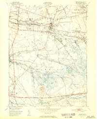
 1949 Pemberton1954 Print · USGSThe Jersey Pine Barrens and the northern edge of the Atlantic coastal plain are captured here just after the war, showing a landscape of transition. Researchers can trace historic industrial sites like Hampton Furnace or locate family landmarks at Sooy Place and Buddtown.2 unique versions available
 - 1949 Map of Pemberton, 1959 Print
 1949 Pemberton1959 Print · USGSMid-century Burlington County comes alive in this survey, capturing the region just as the military and local industry were defining its modern character. Researchers can trace family roots through Vincentown and Birmingham, locate the Brick Kilns, or study the extensive Cranberry Bogs.
 - 1951 Map of Pemberton
 1951 Pemberton1951 Print · USGSBurlington County enters the early fifties with a landscape defined by the Rancocas Creek forks and the expanding presence of the military. Trace local history through the Brick Kilns at Birmingham, the rural crossroads of Comical Corners, and the working Budds Cranberry Bogs.2 unique versions available
 - 1955 Map of Wilmington
 1955 Wilmington1955 Print · USGSThe Delaware Valley and Jersey Shore are seen here during the mid-fifties era of rapid suburban expansion and highway development. You can trace the path of the New Jersey Turnpike, locate the Fort Dix Military Reservation, or explore the rail networks of the Pennsylvania Railroad.
 - 1957 Map of Wilmington
 1957 Wilmington1957 Print · USGSThe mid-Atlantic coastal plain comes alive in the mid-fifties as the New Jersey Turnpike and Garden State Parkway redefine travel. Researchers can trace the rail-to-road transition and find landmarks like Ship John Shoal Light and the Fort Dix Military Reservation.2 unique versions available
 - 1957 Map of Pemberton, 1961 Print
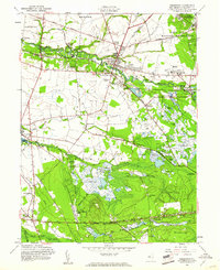 1957 Pemberton1961 Print · USGSMid-century Burlington County comes alive in this survey of the Rancocas Creek watershed during the late fifties. Genealogists and local historians can trace family-named sites from Smithville to Burrs Mill, or locate rural landmarks like Oak Grove Ch and the Cranberry Bogs that defined the local economy.4 unique versions available
 - 1959 Map of Wilmington
 1959 Wilmington1959 Print · USGSThe Delaware Valley and Jersey Shore are seen here in the late fifties, during a period of massive suburban and highway expansion. Researchers can trace mid-century infrastructure like the N J Turnpike or locate coastal landmarks from Barnegat Bay to the Maurice River.3 unique versions available
 - 1966 Map of Wilmington, 1968 Print
 1966 Wilmington1968 Print · USGSThe Delaware Valley and Jersey Shore are seen here in the mid-1960s, documenting a landscape of dense industrial cities and emerging coastal resorts. Researchers can trace the sprawling rail networks of the Pennsylvania Railroad or locate landmarks like Fort Dix Military Reservation and Elk Neck State Park.4 unique versions available
 - 1972 Map of Wilmington, 1976 Print
 1972 Wilmington1976 Print · USGSThe Delaware Valley and Jersey Shore are seen here in the 1970s, showcasing the region's dense transport networks and vast state forests. Trace early coastal development near Atlantic City or locate rural landmarks like Mount Holly and Dover Air Force Base.2 unique versions available
 - 1984 Map of Hammonton, 1986 Print
 1984 Hammonton1986 Print · USGSSouthern New Jersey is captured in the mid-eighties as suburban growth pressed against the vast Pinelands. Researchers can trace the development of the Atlantic City Expressway corridor and locate landmarks like Ancora Psychiatric Hospital and the sprawling Wharton State Forest.3 unique versions available
End of results
Showing maps 1-14 of 14
Top cities near Ewansville
- Philadelphia historical maps
- Hamilton Township historical maps
- Trenton historical maps
- Cherry Hill Township historical maps
- Bensalem Township historical maps
- Levittown historical maps
See more
Frequently asked questions
- What are the different types of historical maps available for Ewansville?
- What is the oldest map of Ewansville?
- Where can I purchase historical maps of Ewansville for my home or office?
- Where can I download high-res historical maps of Ewansville?
- Are there historical topographic maps available for Ewansville?
- Is there historical aerial imagery available for Ewansville?
- Where are historical maps of Ewansville sourced from?