1950s Maps of Camden County, New Jersey
Explore 14 historic maps of Camden County from the 1950s. These maps offer a rare glimpse into what life looked like during the 1950s — showing old roads, neighborhoods, homes, and landmarks that have changed or disappeared over time.
Whether you're researching your family's past, planning a metal detecting trip, or studying how Camden County's landscape evolved across the 1950s, these high-resolution maps are a powerful tool for exploring the history of this region.
- Focus on a specific era: All maps on this page are from the 1950s, giving you a focused view of this time period.
- See what’s changed: Compare century-old streets, trails, and buildings to today's modern landscape using overlays and satellite layers.
- Research with precision: Use these maps for genealogy, historical research, land use analysis, or educational projects.
- View, download, or print: Maps are fully viewable online in high resolution, and can be downloaded or printed for your own records.
Start exploring Camden County's history through authentic maps from the 1950s. This is your window into the past.
Camden County, NJ maps
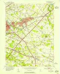
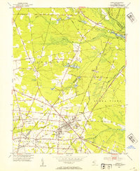
(14)- 1951 Map of Woodbury
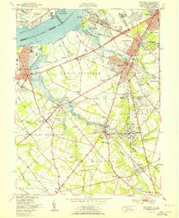 1951 Woodbury1951 Print · USGSGloucester County at the start of the fifties shows a landscape of busy rail corridors and riverfront industry. Trace the Pennsylvania-Reading Seashore Lines through Woodbury and locate the Hog Island Shipyard (Abandoned) or Fort Mifflin along the Delaware.
 - 1952 Map of Runnemede, 1954 Print
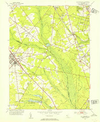
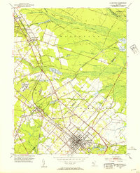
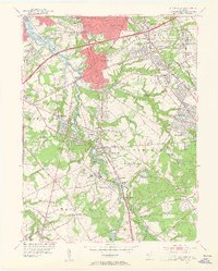 1952 Runnemede1954 Print · USGSCamden and Gloucester counties were undergoing rapid post-war growth when this survey recorded their developing suburban and industrial landscape. Researchers can pinpoint long-standing landmarks like New St Marys Cemetery, Echelon Airport, and the Pennsylvania-Reading Seashore Lines.3 unique versions available
 - 1953 Map of Clementon, 1954 Print
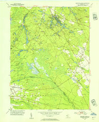
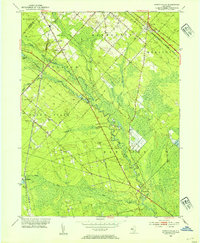
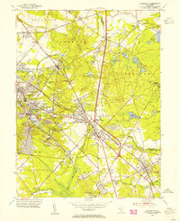 1953 Clementon1954 Print · USGSCamden County was a landscape of rail-linked towns and cranberry bogs in the early fifties. Genealogists and local historians can trace the foundations of Berlin, Gibbsboro, and Atco along the Pennsylvania-Reading Seashore Lines.3 unique versions available
 - 1953 Map of Pitman East, 1954 Print
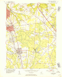 1953 Pitman East1954 Print · USGSGloucester County at mid-century shows a mix of growing college towns and rural crossroads connected by the Pennsylvania-Reading Seashore Lines. Local historians can trace the foundations of Glassboro and Pitman, or locate smaller landmarks like Fries Mill, Bunker Hill Ch, and the State Teachers College.2 unique versions available
 - 1953 Map of Atsion, 1954 Print
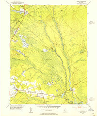 1953 Atsion1954 Print · USGSThe New Jersey Pine Barrens in the early fifties reveal a landscape shaped by water and iron history. Trace the legacy of early settlements and agriculture through the Central Railroad of New Jersey, the sprawling Cranberry Bogs, and historic river crossings at Quaker Bridge.6 unique versions available
 - 1953 Map of Moorestown, 1954 Print
 1953 Moorestown1954 Print · USGSMoorestown and the surrounding Burlington County landscape are captured during the early postwar expansion, just as the New Jersey Turnpike reshaped the region. Genealogists and local historians can trace local family roots through sites like Jacobs Chapel, Cropwell Cem, and the various Township Schools that dotted these rural communities.2 unique versions available
 - 1953 Map of Medford Lakes, 1954 Print
 1953 Medford Lakes1954 Print · USGSThe Pine Barrens of Burlington and Camden Counties appear in detail in the early fifties, showing the region's unique cranberry-based economy. Researchers can trace rural school locations like Louden Sch and agricultural landmarks such as West Jersey Cranberry Meadow.2 unique versions available
 - 1953 Map of Williamstown, 1954 Print
 1953 Williamstown1954 Print · USGSThe Pine Barrens of South Jersey meet the growing hubs of Gloucester and Camden counties in the early fifties. Researchers can trace family sites at Hopewell Cem, follow the PENNSYLVANIA-READING SEASHORE LINES, or locate vanished rail infrastructure like Taggart Siding.
 - 1953 Map of Buena, 1954 Print
 1953 Buena1954 Print · USGSIn the early fifties, South Jersey was a patchwork of small truck farms and rural crossroads centered around Landisville and Minotola. Trace local history through landmarks like St Marys Cemetery, the Downstown Airfield, and Folsom.4 unique versions available
 - 1953 Map of Hammonton, 1954 Print
 1953 Hammonton1954 Print · USGSThe Hammonton area in the early fifties shows the New Jersey Pinelands as a vital hub of rail commerce and cranberry cultivation. Genealogists and historians can trace family locations through sites like Bates Mill Cem, Chesilhurst Sta, and Winslow Junction.2 unique versions available
 - 1953 Map of Newtonville, 1954 Print
 1953 Newtonville1954 Print · USGSThe Pine Barrens of Atlantic County are captured here in the early fifties, showing the vital rail and road links of a rural agricultural landscape. Genealogists can locate family landmarks such as St James Ch and trace the small settlements of Newtonville and Da Costa.5 unique versions available
 - 1955 Map of Wilmington
 1955 Wilmington1955 Print · USGSThe Delaware Valley and Jersey Shore are seen here during the mid-fifties era of rapid suburban expansion and highway development. You can trace the path of the New Jersey Turnpike, locate the Fort Dix Military Reservation, or explore the rail networks of the Pennsylvania Railroad.
 - 1957 Map of Wilmington
 1957 Wilmington1957 Print · USGSThe mid-Atlantic coastal plain comes alive in the mid-fifties as the New Jersey Turnpike and Garden State Parkway redefine travel. Researchers can trace the rail-to-road transition and find landmarks like Ship John Shoal Light and the Fort Dix Military Reservation.2 unique versions available
 - 1959 Map of Wilmington
 1959 Wilmington1959 Print · USGSThe Delaware Valley and Jersey Shore are seen here in the late fifties, during a period of massive suburban and highway expansion. Researchers can trace mid-century infrastructure like the N J Turnpike or locate coastal landmarks from Barnegat Bay to the Maurice River.3 unique versions available
End of results
Showing maps 1-14 of 14
Top cities of Camden County
- Camden historical maps
- Cherry Hill Township historical maps
- Winslow Township historical maps
- Pennsauken Township historical maps
- Voorhees Township historical maps
- Lindenwold historical maps
See more
Frequently asked questions
- What are the different types of historical maps available for Camden County?
- What is the oldest map of Camden County?
- Where can I purchase historical maps of Camden County for my home or office?
- Where can I download high-res historical maps of Camden County?
- Are there historical topographic maps available for Camden County?
- Is there historical aerial imagery available for Camden County?
- Where are historical maps of Camden County sourced from?