1960s Maps of Cherry Hill Township, New Jersey
Explore 5 historic maps of Cherry Hill Township from the 1960s. These maps offer a rare glimpse into what life looked like during the 1960s — showing old roads, neighborhoods, homes, and landmarks that have changed or disappeared over time.
Whether you're researching your family's past, planning a metal detecting trip, or studying how Cherry Hill Township's landscape evolved across the 1960s, these high-resolution maps are a powerful tool for exploring the history of this region.
- Focus on a specific era: All maps on this page are from the 1960s, giving you a focused view of this time period.
- See what’s changed: Compare century-old streets, trails, and buildings to today's modern landscape using overlays and satellite layers.
- Research with precision: Use these maps for genealogy, historical research, land use analysis, or educational projects.
- View, download, or print: Maps are fully viewable online in high resolution, and can be downloaded or printed for your own records.
Start exploring Cherry Hill Township's history through authentic maps from the 1960s. This is your window into the past.
Cherry Hill Township, NJ maps
(5)- 1966 Map of Moorestown, 1968 Print
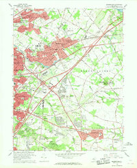 1966 Moorestown1968 Print · USGSBURLINGTON COUNTY in the mid-sixties shows a rapidly evolving suburban landscape defined by new residential developments and critical transit corridors. Researchers can trace the layout of early communities and institutions from Colestown Cemetery to the Moorestown Airport and Mount Laurel State Park.3 unique versions available
 - 1966 Map of Wilmington, 1968 Print
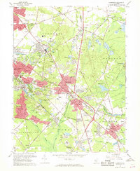
 1966 Wilmington1968 Print · USGSThe Delaware Valley and Jersey Shore are seen here in the mid-1960s, documenting a landscape of dense industrial cities and emerging coastal resorts. Researchers can trace the sprawling rail networks of the Pennsylvania Railroad or locate landmarks like Fort Dix Military Reservation and Elk Neck State Park.4 unique versions available
 - 1967 Map of Clementon, 1968 Print
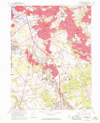
 1967 Clementon1968 Print · USGSMid-century Camden County is caught between its rural origins and suburban growth in this detailed record. Researchers can trace the Pennsylvania Reading Seashore Lines through towns like Gibbsboro and West Berlin, or locate family-named sites such as Tomlinson Mill and Barton.4 unique versions available
 - 1967 Map of Runnemede, 1969 Print
 1967 Runnemede1969 Print · USGSCamden and Gloucester Counties are shown in a phase of rapid postwar growth, where new expressways began to define the local landscape. Researchers can trace the development of suburban boroughs like Hi-Nella and Lawnside or locate the sprawling Lakeland General Hospital complex.4 unique versions available
 - 1967 Map of Camden, 1970 Print
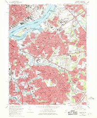 1967 Camden1970 Print · USGSMid-century Camden and Philadelphia face one another across a bustling riverfront connected by the Benjamin Franklin Bridge. Researchers can trace old family roots through numerous landmarks like Harleigh Cemetery, Merchantville High Sch, and the Penn Central rail yards.6 unique versions available
End of results
Showing maps 1-5 of 5
Top cities near Cherry Hill Township
- Philadelphia historical maps
- Camden historical maps
- Bensalem Township historical maps
- Abington Township historical maps
- Washington Township historical maps
- Sicklerville historical maps
See more
Top neighborhoods of Cherry Hill Township
- Brookfield historical maps
- Cherry Hill Estates historical maps
- Columbia Lakes historical maps
- Colwick historical maps
- Tyndall Village historical maps
- Barclay Farm historical maps
See more
Frequently asked questions
- What are the different types of historical maps available for Cherry Hill Township?
- What is the oldest map of Cherry Hill Township?
- Where can I purchase historical maps of Cherry Hill Township for my home or office?
- Where can I download high-res historical maps of Cherry Hill Township?
- Are there historical topographic maps available for Cherry Hill Township?
- Is there historical aerial imagery available for Cherry Hill Township?
- Where are historical maps of Cherry Hill Township sourced from?